During the course of today the City’s disaster response team assisted 63 households that experienced discomfort as a result of the heavy rains that occurred overnight.
The households that were affected are illegally situated in floodplain areas and during heavy rain the water ponds resulting in discomfort as these areas do not have run-off capacity.
The following informal settlement areas were affected:
· BM Section: 28 households (115 persons)
· RR Section: 35 households (105 persons)
The City together with the support of the Western Cape Social Development Department and the South African Social Security Agency provided social relief of distress to the 220 persons.
The SA Weather Services predicts that the Cape Peninsula will experience light showers (30% rainfall) between Saturday and Monday.
The weather system indicates that another cold front is anticipated on Tuesday, Wednesday and Friday with the possibility of 60% of rain.
The City is bracing itself for the low pressure system that is developing and placed all disaster response teams on high-alert.
In the event of a life- or property-threatening emergency, the public are advised to dial 107 from a land-line or 021 480 7700 from a cell phone.
Flooding, blocked drains and service disruptions and power failures can be reported to the City’s 24-hour technical operations centre at 0860 10 30 89.
Motorists who are experiencing delays and deviations on roadways can contact the City’s Transport Information Centre on 0800 65 64 63 for more information.
End
Issued by: Disaster Risk Management Centre, City of Cape Town
Wilfred Schrevian Evan Solomons-Johannes
Head: Systems Integration, Special Projects
Acting Head: Disaster Operations Centre
Saturday, 30 June 2012
SA National Severe Weather Warning: 30 June 2012 16h00 SAST
Eastern Cape Province - Warning: Take action
Subject: Heavy swellDetail: Valid: 30-06-2012 to 01-07-2012 Heavy swell with wave heights in excess of 4.0m is expected between Plettenberg Bay and East London.
Western Cape Province - Warning: Take action
Subject: Heavy swellDetail: Valid: 30-06-2012 to 01-07-2012 Heavy swell with wave heights in excess of 4.0m is expected between Cape Columbine and Plettenberg, subsiding from the west.
All other Provinces - No warnings nor advisories in effect
Subject: No AlertsDetail: No Alerts
- SAWS
SA Weather Satellite Image: 30 June 2012 15h00 SAST

Image: Eumetsat (Click on image for larger view.)
SAWS Storm Warning for Johannesburg - 30 June 2012 15h00

30 June 12 Norwood : SAWS Warning for Johannesburg. Very odd – no sign of cloud near or far?? Obs. B & L Cohen
SAWDOS - Any thunderstorms in the Johannesburg area this afternoon?
UPDATE: 1 July 2012 - Thanks to all those who confirmed that there was no thunderstorm activity yesterday afternoon. I just thought that my crystal ball is broken as I could not see any clouds over Gauteng yesterday afternoon. Like somebody commented: ..... only clouds over Johannesburg were clouds of smoke. For more comments go to the SAWDOS Facebook Group.
Klerksdorp air show crash being investigated
Johannesburg – The cause of a crash at the Klerksdorp Air Show that killed the L-39 Albatros’ pilot on Saturday morning is still unknown, said authorities.
"We are not certain what caused the crash. It's only been a couple of hours," said North West department of community safety spokesperson Simon Mope.
Mope said the cause of the crash would need to be investigated.
Investigators from the Civil Aviation Authority were at the scene to assess the situation.
Earlier the SA National Defence Force confirmed the Albatros was a civilian aircraft.
The pilot's identity could not be made public as his next of kin needed to be informed.
Mope said no one else was injured in the crash, but the road next to the airport leading to Stilfontein was still closed as debris littered the road.
- SAPA/News24
Heat, storms bring misery to millions in US
(CNN) -- Millions of people across nine states were left without power Saturday to deal with thermostat-popping temperatures after a fierce line of thunderstorms and high winds pounded parts of the Midwest and Atlantic Seaboard.
Two people were killed in Virginia, crushed by felled trees, police said.
The storms moved east from Indiana through Ohio and into West Virginia and the nation's capital, according to utility companies.
In all, nearly 4 million homes were left without power; 1 million in Virginia alone.
The aftermath of the storm was compounded Saturday by a forecast of another sweltering summer day.
Temperatures tipped the 100-degree mark Friday in St. Louis, Richmond, Nashville, Washington and Atlanta, the National Weather Service said.
In many places, it felt much hotter than the thermostat reading.
"If you don't have a good pair of boots, it'll burn clear through to your feet," said roofer Zach Bruner in Evansville, Indiana, where he said the 103-degree temperatures were spiking to 130 on the job site.
The bad news? Relief is nowhere in sight as the extreme heat is expected to continue through the weekend.
Fueled by the high temperatures, the severe thunderstorms brought with them winds gusting to 80 miles per hour, the weather service said.
Saturday morning, the storm's fury was visible with downed trees and debris littering roads.
Catherine Estelle Ford of Scottsville, Virginia, died when she stepped out of her car and was trying to make a phone call when a tree fell on her, according to the Albemarle County Police Department.
A second person in Virginia died in similar fashion, said Sgt. Matthew Powers.
The Jackson County medical examiner in western Missouri is investigating three deaths that may be related to the heat, according to the Kansas City Health Department.
The National Weather Service issued an excessive heat warning through Sunday for eastern Missouri, including St. Louis, where temperatures are expected to soar up to 106 this weekend.
"Heat-related illness such as heat exhaustion or heat stroke are a real threat," the weather agency said. "This is especially true because of the longevity of this heat wave and the effects of extreme heat are cumulative."
In Memphis, where highs hit 105 degrees Friday, firefighters went door to door, checking on residents. Churches and faith-based institutions were also urged to ask people to check on their neighbors and relatives.
"Please, if you know of someone who doesn't have air conditioning or who might be struggling with the heat, just stop by and see how they are doing," Mayor A.C. Wharton Jr. said.
The weather service posted excessive heat warnings for 12 states, from Nebraska to New Jersey, with watches and advisories posted for at least six other states.
Baltimore Mayor Stephanie Rawlings-Blake activated the city's emergency operations to coordinate storm recovery operations. In West Virginia, Gov. Earl Ray Tomblin declared a state of emergency for the entire state after the powerful storms.
Atlanta opened cooling centers as the heat index was expected to soar to 110 degrees Saturday.
And at the Congressional Country Club, play was suspended in the third round of the AT&T National as trees and tents came crashing down and the PGA venue was left without power.
The third round was slated to begin at 7:10 a.m. Saturday, but the course lay eerily empty as the tournament announced it was closed to all fans in the interest of safety.
The tournament website simply said: "Stay tuned for details."
- CNN
1 killed as plane crashes at Klerksdorp Air Show

Johannesburg - The aircraft which crashed at the Klerksdorp Air Show in the North West province on Saturday morning was privately owned, the SA National Defence Force (SANDF) said.
Spokesperson Siphiwe Dlamini said the aircraft was an L-39 Albatros which does not belong to the Air force.
Civil Aviation Authority spokesperson Frans Motaung confirmed the crash and said investigators were on their way to the scene.
He could give no further details.
Earlier, paramedics said a SANDF pilot flying a Viper was killed.
The pilot was attempting an aerial manoeuvre when the aircraft crashed, bursting into flames on impact, Netcare 911 spokesperson Jeffrey Wicks said.
"The cause of the crash and the series of events preceding it remain uncertain and will form the subject of a Civil Aviation Authority investigation."
Further details were not immediately available.
- SAPA
Obama pledges federal aid on Colorado wildfire visit

(Reuters) - President Barack Obama on Friday promised federal assistance for Colorado's worst-ever wildfire as he toured damage caused by the blaze, which has killed two people, destroyed hundreds of homes and forced the evacuation of 35,000 residents in and around the state's second-largest city.
Obama began his three-hour visit with an Air Force One fly-over of the area left devastated by a blaze that has raged for a week near the base of the famed Pikes Peak mountaintop, while fire crews, taking advantage of more favorable weather, gained additional ground against the flames.
The so-called Waldo Canyon Fire unleashed its greatest fury on Tuesday night when, stoked by strong, erratic winds, it roared into foothill communities in the northwestern corner of Colorado Springs and threatened the U.S. Air Force Academy campus in town.
Lighter winds since then have helped firefighters, numbering over 1,000 by week's end, make greater headway in corralling the flames. By Friday afternoon, they had managed to carve containment lines around 25 percent of the fire's perimeter, up from 15 percent on Thursday.
As of Friday, the fire had scorched nearly 17,000 acres of timber and brush, much of it in the Pike National Forest west of Colorado Springs, a city of more than 400,000 inhabitants about 50 miles south of Denver.
While fire officials said 20,000 homes remained threatened by the blaze, evacuation orders were lifted for some of the estimated 35,000 residents chased from their dwellings earlier this week.
But progress against the blaze was accompanied by grim news as authorities confirmed the full extent of destruction from Tuesday's firestorm - 347 homes destroyed, most of them in the upscale subdivision known as Mountain Shadows.
The tally of homes consumed by the Waldo Canyon blaze ranks as the most on record for Colorado, surpassing the 257 homes destroyed recently by a much larger blaze north of Denver.
Aerial photos of devastation unleashed by the fire showed large swaths of neighborhoods reduced to gray ash - one house after another obliterated while adjacent dwellings survived mostly unscathed.
Also on Friday, Colorado Springs Police Chief Peter Carey said a second body was found in the debris of a burned-out home. The discovery of the first was announced late on Thursday.
Their deaths bring to six the number of people who have perished so far this year in a Colorado wildfire season described by the governor as the worst ever in the state.
FIRE ACROSS THE WEST
"This has been a devastating early fire season for Colorado. This community, obviously, is heartbroken by the loss of homes," Obama said to reporters as he walked along a street of burned-out houses. "We're lucky, because of the quick action that's been taken, that we haven't seen a lot of loss of life."
Obama's motorcade drove through a neighborhood dotted with houses that remained intact next to others that had burned to the ground, rolling past the melted remains of a children's play area and shells of cars destroyed in the inferno.
The president capped his trip by visiting with evacuees at an emergency shelter operated by the American Red Cross.
One of them, Angi Stoffel, 39, recalled the terrifying moments before she and her family were forced to flee.
"The grass back behind our house has been burned, so I guess we're kind of close," she said. "That first night was horrible. It was very scary, so we went all the way to Pueblo just to get away and try to get our thoughts together and get a game plan."
Waldo Canyon was among nearly 50 large, uncontained wildfires being fought across the United States, the bulk of them in 10 western states - Colorado, Montana, Wyoming, Utah, Idaho, South Dakota, Arizona, New Mexico, Nevada and even Hawaii, according to the National Interagency Fire Center.
As of Thursday, 21 heavy airplane tankers continued to fly in and out of firefighting action across the Western states, joining 170 helicopters, 550 fire engines and more than 8,800 personnel on wildfire lines around the country, said White House spokesman Jay Carney. He said about half of all active federal wildfire-fighting resources were currently staged in Colorado.
Obama announced that federal money would be made available to local agencies and individuals affected by the fire.
"We have been putting everything we have into trying to deal with what is one of the worst fires we've seen here in Colorado," Obama said, speaking at a fire station where he shook hands with firefighters and praised them for their courage. But he added: "We've still got a lot more work to do."
While authorities began allowing some evacuees to return Thursday night, hundreds of residents from neighborhoods caught in the heart of a major firestorm on Tuesday remained displaced.
The FBI is investigating whether any of the wildfires were started by criminal activity, but the cause remains unknown.
The fire menacing Colorado Springs follows a recent string of suspected arson fires in a neighboring county, but officials said they had no indication the blaze was deliberately set.
Although federal authorities say the fire season got off to an early start in parts of the Northern Rockies, the number of fires and acreage burned nationwide is still below the 10-year average for this time of year, according to fire agency records.
(Additional reporting by Joseph O'Leary and Ellen Miller; Writing by Mary Slosson; Editing by Paul Simao and Todd Eastham)
- Reuters
Boy in serious condition after rabies bite
Johannesburg - A 4-year-old boy in KwaZulu-Natal remains in a serious condition after he was bitten by dog infected with rabies, said the provincial department of environmental affairs on Saturday.
"We believe he was bitten by two separate dogs," spokesperson Jeffrey Zikhali said.
The department said it believed the boy was bitten in April in the Umlazi area. He now remained in Durban's Prince Mshiyeni Memorial hospital.
"The department picked up those two dogs and they both tested positive for rabies. The boy has been tested for rabies using saliva tests, a biopsy and a spinal cord tests, but the boy remains negative... but results are for some medical reason sometimes negative."
He said the boy was on a feeding tube and they were keeping their fingers crossed as this was the fourth infection this year.
A campaign to fight rabies has seen over 200 000 dogs vaccinated against the disease.
"We have got a huge campaign in the province and we were boosted by a R16m donation from the World Health Organisation. Since the middle of May we have vaccinated about 200 000 dogs," he said.
Three people have died of rabies in the province this year.
Underberg farmer Graeme Anderson, aged 29, died earlier this month after an abrasion on his hand was licked by a rabid dog.
A 52-year-old woman from Durban was bitten by a neighbour's dog in March and died in May after exhibiting rabies symptoms. And 8-year-old boy from Bergville died in May after being bitten by their family dog the month before.
- SAPA/News24
Weekend of carnage on Gauteng roads
Johannesburg - Two people have been killed and 46 injured in three separate accidents in Gauteng over the weekend thus far, paramedics said on Saturday.
In two separate incidents, two women were killed after the taxis they were travelling in rolled and they were flung out of the vehicles, said Netcare 911 spokesman Jeffrey Wicks.
In the most recent accident a woman died and five people were injured when a minibus taxi overturned on the M1 near Grayston Drive.
“Initial reports indicated that the minibus had collided with a truck, however when arriving on scene, medics were unable to confirm this.”
He said the taxi, which was travelling on the southbound carriageway at the time of the accident, rolled several times.
The woman was flung out of the vehicle and subsequently died from critical injuries.
The five injured were taken to Edenvale State Hospital by ambulance.
Just before 7am, another woman was killed in Faerie Glen in Pretoria when two minibus taxis collided.
Twenty two other people were injured in the accident.
On Friday night, nineteen people were injured, 12 seriously, when a minibus taxi and car collided head on, on Adcock Road in Dobsonville, Soweto.
- Sapa/IOL
SA National Severe Weather Warnings: 30 June 2012 04h00 SAST
Eastern Cape Province - Warning: Take action
Subject: Very rough seasDetail: Valid: 30-06-2012 Very rough seas with wave height between 4 and 6m is expected between Plettenberg Bay and East London on Saturday.
Western Cape Province - Warning: Take action
Subject: Very rough seas.Detail: Valid 30-06-2012: Very rough seas with wave heights between 4 to 6m is expected between Cape Columbine and Plettenberg Bay Saturday.
All other Provinces - No warnings nor advisories in effect
Subject: No AlertsDetail: No Alerts
- SAWS
SA Weather Satellite Image: 30 June 2012 06h00 SAST

Image: Eumetsat (Click on image for larger view.)
GFIMS Global Fire Alerts - South Africa

Your Area of Interest (Country) : South Africa
Fires detected over the past 24 hours in your area-of-interest : 229
(NOTE: Cloud cover might obscure active fire detections. The fire points will be listed only when the total number of active fires detected is less than or equal to 50)
This email was generated on 2012-06-30 , 04:01:55 UTC.
- UN-FAO/UMD/NASA
Blitsige optrede keer brand in kompleks

Malcolm Hyman (heel regs) en lede van die Mosselbaai Brandweer bekyk die uitgebrande motorhuis waar die brand uitgebreek het. Die motorhuis is as stoorplek gebruik. Foto: Cornelle Carstens
MOSSELBAAI NUUS - 'n Brand wat in die vroeë oggendure van Dinsdag, 26 Junie uitgebreek het, is danksy vinnige optrede geblus voordat dit na aangrensende wooneenhede in die Heidepark sekuriteitskompleks in Heiderand kon versprei.
Malcolm Hyman, 'n verkoopsverteenwoordiger en die inwoner van die eenheid waar die brand uitgebreek het, was vroeër die aand besig in die motorhuis, wat dien as stoorruimte vir van sy voorraad bestaande uit lekkergoed, skyfies en snoeperye.
Rondom 00:30 het hy voor die televisie ingesluimer en het omstreeks 01:00 wakkergeskrik van 'n geluid wat soos 'n harde donderslag geklink het. By nadere ondersoek het hy besef dat die motorhuis van binne aan die brand geslaan het. Sy buurman was dadelik op die toneel.
Een van die lede van die Mosselbaai Brandweer woon toevallig ook in die kompleks en danksy die blitsige optrede van die res van die brandweerspan, is die brand spoedig onder beheer gebring. Die voorraad wat in die motorhuis gestoor was, het in die slag gebly, asook heelwat sentimentele items.
Die Hyman-egpaar en hulle twee seuns, onderskeidelik 14 en 12 jaar oud, woon sedert Oktober 2011 in die kompleks.
Alhoewel daar teen druktyd nog nie uitsluitsel oor die oorsaak van die brand was nie, bestaan die vermoede dat dit as gevolg van 'n elektriese kortsluiting kon wees.
- Mossel Bay Advertiser
Floods Cause Major Disruption in Britain, Ireland
Flash floods triggered by heavy rain across Britain and Ireland have inundated homes, submerged roads and cut off both main railway lines linking England and Scotland.
Network Rail said sections of the Glasgow-to-London and the Edinburgh-to-London lines were blocked by landslides Thursday.
Torrential rain, following weeks of wet weather, has triggered floods across central and northern England, as well as in Scotland and Northern Ireland.
Police said a man in his 60s was killed when he was swept away near Ludlow, central England.
In Belfast, Northern Ireland, floodwater swamped houses, made roads impassible and left 1,000 homes without power late Wednesday.
The Environment Agency imposed 12 flood warnings and 62 less serious flood alerts across the country Thursday.
- ABC News
Extreme heat spreads across U.S., could break records
Source: reuters // Reuters
By Kevin Murphy
KANSAS CITY, Mo, June 28 (Reuters) - The Midwest cities of Cincinnati, St. Louis, Chicago and Kansas City could approach or break heat records on Thursday, as a massive high pressure system sent temperatures higher throughout most of the country.
Drought conditions have contributed to the early and sustained heat, according to Alex Sosnowski, expert senior meteorologist at AccuWeather.com. He said both St. Louis and Kansas City, Missouri could hit 107 degrees Thursday. The high temperatures will move into the northeast Friday.
"A lot of these places haven't had a lot of rain, and dry soil contributes to heat," Sosnowski explained, when asked why the high temperatures are being seen so early in the summer. "The sun's energy doesn't go into evaporating moisture, so it heats the ground and that heats the air. It takes a really big rainfall event to bust a drought like this."
Though scattered thunderstorms are expected to throttle back the heat in the Midwest for Friday, Sosnowski does not see anything that would make much of an impact in dry areas.
The weather conditions have contributed to wildfires blazing across Colorado which have destroyed hundreds of homes.
The high temperatures and drought conditions also are damaging crops - U.S. corn prices have soared 17 percent this month as the hot dry weather persists in the main growing area of the Midwest.
For the fifth day in a row Wednesday, no place in the country was hotter than Hill City, Kansas, a farming community in the northwest part of the state. Hill City and Phillipsburg, Kansas tied for the nation's hottest spot on Wednesday at 115 degrees, according to the National Weather Service. The Thursday forecast is 109 degrees.
"It feels like you have a big old furnace blowing in your face," said Rayson Brachtenbach, a technician at Elliott Plumbing, Heating, Air Conditioning and Electric in Hill City.
Brachtenbach said the hot weather has kept Elliott busy repairing air conditioning systems with compressors lacking the capacity to cool houses in the extreme heat. "Five or six days around 115 degrees is really hard on them," he said.
A city in the Midwest having the nation's high temperature for five days in a row is very unusual, said Chris Foltz, a meteorologist for the NWS in Goodland, Kansas.
"It's what you expect in the desert of Nevada or California," Foltz said. "Hill City is where the high pressure is anchored. It's like the heat perpetuates itself."
In Chicago, summer school was closed Thursday for 10 public schools that lack air conditioning.
In Indiana, burn bans are in effect 74 of 92 counties, and 45 counties have restrictions on shooting off fireworks.
Continuing high temperatures in the south have led the Birmingham, Alabama, police to decide to check on the sick and elderly through Sunday.
"We want to ensure our citizens remain safe during the excessive heat outbreak," said Birmingham Police Chief A.C. Roper. (Reporting by Mary Wisniewski, Kevin Murphy, Christine Stebbins, Keith Coffman, and Susan Guyett; Editing by Greg McCune and Jackie Frank)
- AlertNet
Europe's cities plan to combat mounting climate risk
Source: reuters // Reuters
* Report surveyed 22 European cities on climate strategies
* Cities doing risk assessments, developing adaptation plans
* Becoming more aware of emissions impact, opportunities (Adds detail on Rotterdam, Berlin emissions in para 13)
By Nina Chestney
LONDON, June 28 (Reuters) - European cities are planning to adapt to climate change as the risks become more severe, a report by UK-based emissions measurement organisation the Carbon Disclosure Project (CDP) and consultancy Accenture showed on Thursday.
Cities increasingly have to plan flood defences, ways to manage water in times of drought, ensure new buildings provide natural cooling to occupants and adapt old buildings and infrastructure to become more energy efficient.
The report surveyed 22 European cities - including Amsterdam, Berlin, Istanbul, London, Manchester, Moscow, Paris and Rome - about their greenhouse gas emissions and climate change strategies.
The report comes less than a week after a United Nations' summit in Rio de Janeiro failed to define clear sustainable development goals and left many convinced that local governments and businesses will have to lead efforts to improve the environment.
The survey found that 17 European cities out of the 22 surveyed, or 77 percent, have completed or almost completed risk assesments to understand how climate change will affect them.
Eighteen of the 22 European cities said they face "significant risks" arising from climate change and 54 percent of them see these risks as "severe" or "very severe".
Due to these risks, cities are increasingly looking at developing adaptation plans. Fourteen European cities, or 64 percent of the 22 surveyed, already have an adaptation plan in place while two more are currently developing them.
"European cities are demonstrating leadership and best practice in managing climate change at the local level," said Conor Riffle, head of CDP's cities programme.
"The report shows that other cities can benefit by implementing similar strategies, like annual measurement and reporting of greenhouse gas emissions."
EMISSIONS
Global carbon dioxide emissions, one of the main greenhouse gases blamed for global warming, hit a record high last year, according to the International Energy Agency.
Eighty-six percent of the European cities surveyed have set a city-wide emissions reduction target, compared to a global average of 70 percent of cities, CDP said.
Based on the latest data given by four cities to CDP, London's emissions fell 3.6 percent to 43.4 million tonnes of carbon dioxide equivalent in 2010 from 2008 and Copenhagen's dropped 5.2 percent to around 2.5 million tonnes in 2010 from 2009.
Berlin's emissions rose 4.1 percent to over 20.7 million tonnes of carbon dioxide emissions in 2008 from 2007 and Rotterdam's grew by 6 percent in 2010 to 29.6 million tonnes from 2009.
"Population growth, economic activity, weather patterns, and other factors that are outside the city government's direct control can make it difficult, if not impossible, to show steady reductions in emissions," the report said.
European cities are also becoming more aware of the economic opportunities from climate change. Thirteen of the cities surveyed, or 59 percent, think that tackling climate change will develop new business industries in their cities.
Some cities - like Helsinki and Berlin - are using voluntary agreements with the private sector to strengthen their cities' climate protection goals. (Editing by William Hardy)
- AlertNet
346 homes confirmed lost in Waldo Canyon Fire

Waldo Canyon Fire Damage. June 27, 2012. Courtesy John Wark.
COLORADO SPRINGS, Colo. – Authorities confirmed Thursday at least 346 homes have been destroyed by the Waldo Canyon Fire, making it the most destructive wildfire in Colorado history.
Colorado Springs Mayor Steve Bach delivered the somber news at an afternoon press briefing, saying individual homeowners would be notified of their losses during an evening meeting for residents only.
“This is going to be a tough evening, but were going to get through it,” said Bach. “This community is going to mount an unprecedented response to this.”
Bach said the assessment is preliminary and the number of homes destroyed could rise.
“This community is going to surround (the fire victims) with love and encouragement, and we’re going to move forward as a city like we never have,” Bach said.
Containment of the 18,500-acre fire improved to 10-percent Thursday and fire commanders reported “significant progress” toward strengthening containment lines.
Evacuation orders were lifted at 8 p.m. for residents on the east side of the fire perimeter, including Kissing Camels, Holland Park, Pine Cliff, Pleasant Valley and portions of Rockrimmon.
The cause of the fire remains under investigation.
The Waldo Canyon Fire now surpasses the 87,000-acre High Park Fire in Larimer Fire (257) in terms of homes lost.
133 homes were destroyed in 2002’s Hayman Fire.
- FOX31
Smoke Spreading from Zambia into Angola and Botswana – July 29th, 2012

Smoke spreads from Zambia (upper right) into Angola (upper left) and Botwana (lower right). Namibia (lower left), remains unaffected. Although the thumbnail image shows a cloud of smoke, upon opening the full image multiple blazes can be pinpointed in Zambia and near the Caprivi Strip, or “Four Corners” region where Botswana, Namibia, Zimbabwe and Zambia near form a quadruple frontier. Also of note in the image is the Okavango Delta (lower right quadrant) and the salty white surfaces of the Etosha (left) and Makgadikgadi (right) Pans.
- EARTH SNAPSHOT
Fontenelle Fire in Wyoming

The Fontenelle Fire was discovered on June 24, 2012, in Bridger-Teton National Forest about 33 miles (53 kilometers) northwest of LaBarge, Wyoming. By June 29, it had burned 22,826 acres (9,237 hectares). The fire, which was likely started by a downed power line, was moving rapidly through dead timber and had affected gas, oil, and helium production in the area. The Moderate Resolution Imaging Spectroradiometer (MODIS) on NASA’s Aqua satellite captured this image of the fire on June 28, 2012. Thick smoke, partially obscured by clouds, is visible blowing toward the northeast. The red outlines indicate hot spots where MODIS detected the unusually warm surface temperatures associated with fires.
References
- Inciweb. Fontenelle Fire. Accessed June 29, 2012.
- Trib.com. Bridger-Teton Fire Makes Big Run as New Fires Erupt. Accessed June 29, 2012.
NASA image courtesy Jeff Schmaltz, LANCE MODIS Rapid Response Team, Goddard Space Flight Center. Caption by Adam Voiland.
- Instrument:
- Aqua - MODIS
Tropical Storm Doksuri

Doksuri formed as a tropical depression over the western Pacific Ocean on June 26, 2012, and strengthened to a tropical storm the same day, Unisys Weather reported. One June 29, 2012, the U.S. Navy’s Joint Typhoon Warning Center (JTWC) reported that Doksuri was located roughly 100 nautical miles (185 kilometers) south-southeast of Hong Kong. The storm had maximum sustained winds of 40 knots (75 kilometers per hour) with gusts up to 50 knots (95 kilometers per hour). The JTWC storm track projected Doksuri continuing its westward movement in the direction of southern China.
The Moderate Resolution Imaging Spectroradiometer (MODIS) on NASA’s Terra satellite captured this natural-color image of Tropical Storm Doksuri on June 29, 2012, as the storm hovered over the South China Sea.
On June 29, Focus Taiwan reported that Taiwan’s weather bureau had canceled a high-sea warning, but nevertheless cautioned residents about potentially heavy rainfall in eastern and southern Taiwan. Meanwhile, Chinese authorities urged preparation for the storm, also warning of rainfall.
References
- Focus Taiwan New Channel. (2012, June 29) Weather bureau lifts sea warning for Tropical Storm Doksuri. Accessed June 29, 2012.
- Joint Typhoon Warning Center. (2012, June 29) Tropical Storm 07W (Doksuri) Warning. [Online] URL: http://www.usno.navy.mil/NOOC/nmfc-ph/RSS/jtwc/warnings/wp0712web.txt. Accessed June 29, 2012.
- Unisys Weather. (2012, June 29) Doksuri Tracking Information. Accessed June 29, 2012.
- Xinhua. (2012, June 28) Authorities urge preparation for tropical storm Doksuri. Accessed June 29, 2012.
NASA image courtesy Jeff Schmaltz, LANCE MODIS Rapid Response Team at NASA GSFC. Caption by Michon Scott.
- Instrument:
- Terra - MODIS - NASA
Mount Etna, Not Quite Restful

Mount Etna belches out volcanic gases in this natural-color satellite image. Relatively quiet since its last paroxysm on April 24, 2012, the volcano still emits a lively, blue-tinted plume. These gases are emitted from the Northeast Crater, while most recent lava flows (25 since January 2011) have erupted from the new Southeast Crater, lower down the mountainside. This image was collected by the Advanced Land Imager (ALI) aboard the Earth Observing-1 (EO-1) satellite on June 26, 2012.
- Behncke, Boris. (2012, June 27). Over Etna, June 2012. Accessed June 28, 2012.
- INGV Sezione di Catania. (2012, April) The 24 April 2012 Paroxysm of Etna. Accessed June 28, 2012.
NASA image By Jesse Allen and Robert Simmon using EO-1 ALI data. Caption by Robert Simmon.
- Instrument:
- EO-1 - ALI
Friday, 29 June 2012
Earthquake Magnitude Classification: South Atlantic Earthquake

GEOFON South Atlantic Ocean Jun 29 15:31 PM 5.8M 10.0 Depth
USGS South Atlantic Ocean Jun 29 15:31 PM 5.8M 10.0 Depth
EMSC South Atlantic Ocean Jun 29 15:31 PM 6.0M 10.0 Depth
Red color = CONSIDERABLE risk for damage or injuries
- Earthquake Report
Earthquake Magnitude 5.8 - SOUTH ATLANTIC OCEAN 2012 June 29 15:31:46 UTC

Earthquake Details
- This event has been reviewed by a seismologist.
| Magnitude | 5.8 |
|---|---|
| Date-Time |
|
| Location | 24.735°S, 9.723°W |
| Depth | 10 km (6.2 miles) |
| Region | SOUTH ATLANTIC OCEAN |
| Distances | 1060 km (658 miles) SSW of Jamestown, Saint Helena 2472 km (1536 miles) W of Walvis Bay, Namibia 2480 km (1541 miles) W of Swakopmund, Namibia 2502 km (1554 miles) W of Luderitz, Namibia |
| Location Uncertainty | horizontal +/- 16.4 km (10.2 miles); depth +/- 2.8 km (1.7 miles) |
| Parameters | NST=283, Nph=283, Dmin=>999 km, Rmss=1.02 sec, Gp= 43°, M-type=teleseismic moment magnitude (Mw), Version=A |
| Source |
|
| Event ID | usb000atxy |
- USGS
Colorado wildfires: President Obama declares disaster

US President Barack Obama has issued a disaster declaration for Colorado, where wildfires have forced tens of thousands from their homes.
Mr Obama is scheduled to visit the affected area on Friday, as federal funds were cleared to combat the blaze.
One person was declared dead after human remains were found in a burned-out home in Colorado Springs.
The Waldo Canyon fire has destroyed 346 houses, making it the most destructive in the state's history.
On Friday morning, officials said the fire was 15% contained and that favourable weather conditions helped firefighting crews make good progress overnight.
Incident commander Richard Harvey said there had been no perimeter growth of the fire, and no additional structures were lost or damaged.
But the forest service has warned that it could still take weeks to get the wildfires under control.
Another blaze in northern Colorado - the High Park fire - has killed one person and has destroyed 257 homes, officials have said.
Half of America's firefighting resources, some 1,100 personnel, have been deployed in the state, where nearly 160,000 acres have been razed.
Body found
Some mandatory evacuation notices have been lifted, authorities said on Friday, enabling some people to begin returning home.
Many people remain in shelters and officials said that it may take some time to restore gas and electricity services to those who have been allowed to re-enter their houses.
On Tuesday, about 32,000 people were forced to leave their homes as the Waldo Canyon fire surged across the city limits of Colorado Springs, the state's second biggest city and home to some 420,000 people.
Late on Thursday, Police Chief Pete Carey said the remains of a person were found in a gutted house in the city.
He said the body was one of two people reported missing from that address, but did not give further details.
On Friday he said authorities were trying to trace fewer than 10 people who may be unaccounted for.
Officials on Thursday said the fire was halted before it reached the academy for US Air Force cadets. It had been evacuated, but residents were allowed to return on Friday morning.
The authorities informed those who had lost homes on Thursday. Some had already been able to tell if their houses had survived from aerial photos, which showed rows of buildings reduced to ashes.
"Our minds just started sifting through all the memories of that house that we lost that can't be replaced," resident Rebekah Largent told the Associated Press news agency, after learning from lists distributed by the authorities that her house had been among those destroyed.
Colorado Springs Mayor Steve Bach said it would be a difficult time for those affected.
"This community is going to surround them with love and encouragement," Mr Bach said, according to the AP.
The fire, which has caused an estimated $3.2m (£2m) of damage, was 15% contained as of late on Thursday.
President Obama is due to tour the affected areas later on Friday. His decision to declare a disaster in the area makes federal funds available for local relief efforts.
Wildfires are also sweeping parts of Montana, Utah, Wyoming, South Dakota, New Mexico, Nevada, Arizona and California.
- BBC News
SA National Severe Weather Warnings: 29 June 2012 16h00 SAST
Eastern Cape Province - Warning: Take action
Subject: Very rough seasDetail: Valid: 29/30-06-2012 Very rough seas with wave height between 4 and 6m is expected between Plettenberg Bay and Port Alfred from afternoon, spreading to East London on Saturday.
Western Cape Province - Warning: Take action
Subject: Very rough seas.Detail: Valid 29 to 30-06-2012: Very rough seas with wave heights between 4 to 6m is expected between Cape Point and Plettenberg Bay, spreading to between Cape Columbine and Plettenberg Bay Saturday.
All other Provinces - No warnings nor advisories in effect
Subject: No AlertsDetail: No Alerts
- SAWS
SA Weather Satellite Image: 29 June 2012 17h00 SAST

Image: Eumetsat (Click on image for larger view.)
Light Aircraft makes emegency landing near the N1 Walmannsthal area.

Pretoria paramedics responded out to an accident at the corners of Doreen Avenue and Frans du Toit street in Rosslyn, Pretoria where two cars had collided in a side impact collision.
Paramedics arrived on scene to find bystanders performing CPR on an elderly woman at the side of the road. She had allegedly been pulled from her sedan and they were trying to revive her. Upon their initial assessments, there were no signs on life and she was declared dead on scene a short while later.
It appears that one of the vehicles had crossed the two way stop intersection at the wrong time, where another sedan collided into the drivers side of the car the 88 year old was driving.
The driver of the other vehicle was found walking around the scene and he had suffered minor injuries and did not require transportation to hospital by ambulance.
The cause of the collision requires full investigation by the necessary authorities.
As paramedics were finishing up on the scene of the accident, reports came through that a helicopter had gone down near the N1 Walmannsthal area. They made their way to the scene and were redirected to an open field along the N4 near the Dr. Swanepoel road off ramp.
They found a light aircraft stationary in the grassy field. They found the pilot walking around the area. He explained that he had experienced engine failure as he was coming in to land, and he then needed to perform an emergency landing and the best place he could see had been the open field.
Fortunately he had not suffered any injury and he did not need to be taken to hospital by ambulance. The pilot had been the only occupant of the aircraft at the time.
- ER24
U.S., Australia Sign Meteorology Science Exchange Agreement
(Collaboration intended to improve weather forecasts, tsunami warning) (440)
Washington - The U.S. National Oceanic and Atmospheric Administration (NOAA) signed an agreement March 23 with Australia's Bureau of Meteorology to work together to improve meteorological and hydrological forecasting.
David Johnson, director of NOAA's National Weather Service, and Australia’s director of meteorology, Geoff Love, signed the agreement as part of a World Meteorological Day celebration in Melbourne, Australia.
"This agreement fosters a mutual exchange of scientific and technical expertise to enhance both countries' capabilities in delivering the most sophisticated meteorological and hydrological data available," Johnson said.
The agreement, he added, is also "an important step in advancing the Global Earth Observation System of Systems [GEOSS], which will be a key part of our ability to forecast and warn of natural disasters on a global scale."
Thousands of individual instruments now gather observations around the globe. Through GEOSS, NOAA is working with federal partners and 60 countries to integrate these instruments in a global monitoring network that allows the instruments to communicate with each other.
The result is more accurate weather forecasts, more effective water and air quality monitoring, improved aviation safety, reduced energy costs and other societal and economic effects.
The five-year U.S.-Australia agreement comes with an implementation strategy by which Australia will adopt the digital forecast process developed by NOAA's National Weather Service.
Through its National Digital Forecast Database, NOAA provides a seamless mosaic of forecast elements to the public to use in creating text, graphic, grid and image products.
NOAA will share the technology with Australia's Bureau of Meteorology to improve forecasts and to provide a standardized protocol for more effective information sharing.
A second part of the agreement involves enhancing international tsunami warning systems.
The technology exchange will help Australia and the United States support the Intergovernmental Oceanographic Commission's Indian Ocean Tsunami Warning System and accelerate Australia's capacity to plan, deploy, apply and operationally support deep-ocean tsunami detection platforms such as the U.S. deep-ocean assessment and reporting tsunamis (DART) buoy stations.
The two nations also will collaborate on designing warning systems and exchanging sea-level data related to the warning systems.
"We are creating a structure and a network of scientists in both countries to share data and to provide technical capabilities," Love said.
Such a network will enhance the understanding of global weather and climate through collaborative research, he added, and will provide a foundation for GEOSS and other international activities.
Information about the National Weather Service, GEOSS and the National Digital Forecast Database are available on the NOAA Web site.
(Distributed by the Bureau of International Information Programs, U.S. Department of State. Web site: http://usinfo.state.gov)
Original document from Washington Hyperfile
Fire causes tragic death of three people in Cross Roads
At 06:11 on Friday, 29 June 2012 a fire occurred at Noxolo Street, Cross Roads.
The fire engulfed one shack resulting in the death of three (3) people.
The mother, Sinoxolo Nyakaza (23 years); her 3 year old daughter Akana; and another 3 year old female minor from Khayelitsha that was visiting the family died in the fire.
The circumstances surrounding the occurrence of the fire are unknown.
The Nyanga SAPS has opened an inquest docket to investigate the incident.
The City of Cape Town expresses its deepest sympathy to the loved ones of the deceased.
Issued by: Disaster Risk Management Centre, City of Cape Town
End
Wilfred Schrevian Evan Solomons-Johannes
Head: Systems Integration, Special Projects
Acting Head: Disaster Operations Centre
SA National Severe Weather Warnings: 28 June 2012 04h00 SAST
Eastern Cape Province - Warning: Take action
Subject: Very rough seasDetail: Valid: 29/30-06-2012 Very rough seas with wave height between 4 and 6m is expected between Plettenberg Bay and Port Alfred from afternoon, spreading to East London on Saturday.
Western Cape Province - Warning: Take action
Subject: Very rough seas.Detail: Valid 29 to 30-06-2012: Very rough seas with wave heights between 4 to 6m is expected between Cape Point and Plettenberg Bay, spreading to between Cape Columbine and Plettenberg Bay Saturday.
All other Provinces - No warnings nor advisories in effect
Subject: No AlertsDetail: No Alerts
- SAWS
SA Weather Satellite Image: 28 June 2012 06h00 SAST

Image: Eumetsat (Click on image for larger view.)
GFS Medium Range Forecasts of Vertical Velocity and Precipitation: 28 - 30 June 2012

Image: U.S. National Center for Environmental Prediction (NCEP) Click on image for larger view.
GFIMS Global Fire Alerts : South Africa

Your Area of Interest (Country) : South Africa
Fires detected over the past 24 hours in your area-of-interest : 228
(NOTE: Cloud cover might obscure active fire detections. The fire points will be listed only when the total number of active fires detected is less than or equal to 50)
This email was generated on 2012-06-29 , 04:02:24 UTC.
- UN-FAO/UMD/NASA
China's Shenzhou-9 spacecraft returns to Earth

A Chinese space capsule carrying three crew members has returned to Earth following a 13-day mission.
Images of the capsule landing in Inner Mongolia at 1005 local time (0205 GMT) were shown live on television.
The astronauts carried out a successful manual docking with the Tiangong-1 laboratory module and performed a series of experiments while in space.
The mission is a key step towards China's goal of building a space station by 2020.
Crew member Liu Yang hit the headlines around the world for being the first Chinese woman in space.
The crew of the Shenzhou-9 craft successfully carried out the country's manual docking manoeuvre earlier in the week.
The delicate procedure, which involves bringing together two orbiting vessels travelling at thousands of miles an hour, was mastered by the USSR and US space teams in the 1960s.
The crew also carried out automatic docking of the two crafts during their mission.
The three astronauts returned to the Shenzhou-9 spacecraft on Thursday and performed a manual separation from the space laboratory.
They touched down in Inner Mongolia's Siziwang county, with the capsule deploying a parachute to slow its approach.
All the astronauts were in good health, Xinhua news agency reported.
The Shenzhou-9 spacecraft was launched on 16 June.
- BBC News
Hundreds of Colorado Springs homes destroyed in fire
Gov John Hickenlooper: "There is nothing firefighters could do when you get this kind of weather"
Hundreds of homes in Colorado Springs have been destroyed by one of dozens of wildfires raging across western US states, officials said.
Some 346 homes on 35 streets have been razed, making it the most destructive fire in the state's history.
Some of the more than 30,000 people who fled the flames in Colorado's second-biggest city on Tuesday night have been told they can return.
President Barack Obama is due to tour the affected areas on Friday.
The fire, which has caused an estimated $3.2m (£2m) of damage, was 10% contained as of midday on Thursday.
"We made significant progress on the ground today," Jerri Marr, a US Forest Service spokeswoman, told reporters.
Some residents who live in the burned neighbourhoods have been able to tell if their homes have been destroyed by looking at aerial photos.

On one street, all but three houses had burned to their foundations, Ryan Schneider told the Associated Press. His home is standing, but 51 others in his neighbourhood were razed.
"I was real happy at first. My wife was happy," he said. "The emotion of seeing the other homes, though, was instant sadness."
Two people have been arrested in connection with a burglary at an evacuated home, Colorado officials said.
Colorado Springs Mayor Steve Bach told residents and reporters he had seen many community members reaching out to help.
"This is going to be a tough evening, but we're going to get through it. We will move forward as a community."
Colorado accounts for eight of 35 large wildfires which are also sweeping parts of Montana, Utah, Wyoming, South Dakota, New Mexico, Nevada, Arizona and California.
In Utah, a body was found in the ashes of a fast-moving wildfire to the south of Salt Lake City.
The Waldo Canyon Fire, which began on Saturday, was fanned towards Colorado Springs by high winds.
The city of 419,000 people is home to the sprawling campus of the academy for US Air Force cadets.
Fires threatening the school have been halted, and cooler conditions prevailed by late Thursday.
- BBC News
Hundreds of homes in Colorado Springs have been destroyed by one of dozens of wildfires raging across western US states, officials said.
Some 346 homes on 35 streets have been razed, making it the most destructive fire in the state's history.
Some of the more than 30,000 people who fled the flames in Colorado's second-biggest city on Tuesday night have been told they can return.
President Barack Obama is due to tour the affected areas on Friday.
The fire, which has caused an estimated $3.2m (£2m) of damage, was 10% contained as of midday on Thursday.
"We made significant progress on the ground today," Jerri Marr, a US Forest Service spokeswoman, told reporters.
Some residents who live in the burned neighbourhoods have been able to tell if their homes have been destroyed by looking at aerial photos.

Aerial views of Colorado Springs show houses reduced to rubble (Click on image for larger view.)
On one street, all but three houses had burned to their foundations, Ryan Schneider told the Associated Press. His home is standing, but 51 others in his neighbourhood were razed.
"I was real happy at first. My wife was happy," he said. "The emotion of seeing the other homes, though, was instant sadness."
Two people have been arrested in connection with a burglary at an evacuated home, Colorado officials said.
Colorado Springs Mayor Steve Bach told residents and reporters he had seen many community members reaching out to help.
"This is going to be a tough evening, but we're going to get through it. We will move forward as a community."
Colorado accounts for eight of 35 large wildfires which are also sweeping parts of Montana, Utah, Wyoming, South Dakota, New Mexico, Nevada, Arizona and California.
In Utah, a body was found in the ashes of a fast-moving wildfire to the south of Salt Lake City.
The Waldo Canyon Fire, which began on Saturday, was fanned towards Colorado Springs by high winds.
The city of 419,000 people is home to the sprawling campus of the academy for US Air Force cadets.
Fires threatening the school have been halted, and cooler conditions prevailed by late Thursday.
- BBC News
Adult male dies in fire at Nyanga
At 06:00 on Thursday, 28 June 2012 a fire occurred at Mau-Mau Informal Settlement, off Emms Drive, Nyanga.
The fire engulfed one shack resulting in the death of Bhukile Ngesi, aged 26 years.
The swift response of the Fire & Rescue Services prevented the fire from spreading to other structures in the area.
The circumstances surrounding the occurrence of the fire are unknown.
The SAPS has opened an inquest docket to investigate the incident.
Issued by: Disaster Risk Management Centre, City of Cape Town
End
Wilfred Schrevian Evan Solomons-Johannes
Head: Systems Integration, Special Projects
Acting Head: Disaster Operations Centre
Hunt for lost plane reveals another in Russia

AN-2 Antonov Colt.
Image by: Catalan / Wikimedia Commons
Russian rescuers looking for a small plane that inexplicably vanished this month stumbled on the remains of a similar plane that crashed six years ago.
They also found a downed helicopter.
The bizarre turn of events added a peculiar twist to the mystery of what happened to an ageing Antonov An-2 biplane that took off without permission from a disused airfield near the Ural Mountains steel mill town of Serov.
State television crews have since travelled to Serov to interview locals who have remained almost unanimously tight-lipped about what happened on the weedy air strip on the evening of June 11.
Police have already probed theories of the An-2 being taken over by some friends who decided to go on a fishing trip after a long weekend party and the plane being used in some ill-conceived recreational flight scheme.
The An-2 hunt is still being officially called a "search and rescue" mission because there is no confirmation of the plane going down -- and no recorded radar evidence of it ever having taken off from the airport.
But the region's emergencies ministry said Thursday it did find the remains of a Soviet-era An-2 that crashed in 2006.
It also noted spotting the remains of a helicopter at the same location. The two had apparently crashed but officials reported no details.
"The findings have no relation to the missing An-2 whatsoever," the regional ministry announced.
Russian media speculate that up to 12 people may have been on board the single-engined propellor-driven An-2 when it took off from Serov.
State television has further suggested that city authorities had ordered instructions for the locals not to cooperate with the investigation out of fear that they might become implicated in unspecified crimes.
Rescuers have reported scouring some 220,000 square kilometres (85,000 square miles) of land from the air and another 1,000 square kilometres by foot without finding anything but the two old wrecks.
- Times Live
Parallel Plumes of Smoke from Fires in Central Russia

A state of emergency is still in effect in Russia due to fires burning near the borders of Khanty-Mansiisk, Krasnoyarsk, and Tomsk. Here, plumes of smoke from dozens of blazes blow parallel to each other in a southerly direction. Russian authorities have announced that the fires were caused by a variety of reasons, including lightning strikes and people losing control of agricultural fires and campfires.
- Earth Snapshot
27 dead, 900,000 displaced in Indian floods

School girls and a man carrying his bicycle wade through floodwaters after heavy rains at Jajimukh village in the northeastern Indian state of Assam.
Image by: STRINGER/INDIA / REUTERS
At least 27 people have died and 900 000 others have been forced to leave their homes as monsoon rains swamp wide areas of the Indian state of Assam.
A state government spokesman said 21 of Assam's 27 districts were hit by flash floods which began last weekend as the rains lashed the tea and oil-rich Indian state.
"So far, 27 people have died in separate incidents including five who were killed when their boat sank," Assam Agriculture Minister Nilamoni Sen Deka told AFP in Guwahati, the state's largest city.
He also said the Brahmaputra river was overflowing its banks in many places.
Deka said an estimated 900 000 people had been displaced from their homes due to the flooding.
"Most of the displaced people have been forced to take shelter on raised platforms and in tarpaulin tents," Deka added.
"All major rivers are running menacingly high with breaches reported in many places," added Assam health minister Himanta Biswa Sarma as rescuers set up 1 500 temporary shelters for people stranded.
In nearby Bangladesh, the death toll from a series of flash floods and landslides rose above 100 on Thursday.
The annual monsoon, crucial to India's food production and economic growth, arrived over the tropical country earlier in the month.
Indian agriculture gets 60 percent of its precipitation from the rains and a bad monsoon can spell financial disaster for the country's 235 million farmers.
-Sapa/Times Live
Sanctuary Ranger attacked by Chimps fights for life
A ranger at a Chimpanzee sanctuary near Nelspruit is fighting
for his life after he was attacked by two frenzied animals while leading a tour
group at the park this afternoon.
The cause of the incident and the series of events preceding
it remain unclear.
Common cause information suggests that the ranger had lead
the tour passed an enclosure and had positioned himself close to the fence.
According to eyewitnesses, two Chimpanzees’ grabbed the man by his feet and
pulled him under the perimeter fence and into the enclosure.
The man was dragged nearly a kilometer into the large
enclosure while being attacked by the two animals.
Netcare911 Paramedics arrived at the scene and entered the
enclosure with armed escorts. They arrived to find the ranger in a critical
condition, having sustained multiple and severe bite wounds. He was rapidly
stabilised at the scene and transported by ambulance to a private medical
facility in Nelspruit.
No one else was injured in the incident.
Jeffrey Wicks
Media Liaison Officer - Gauteng
Netcare LimitedNetcare 911
Media Liaison Officer - Gauteng
Netcare LimitedNetcare 911
Stellar Flare Blasts Exoplanet
June 28, 2012: An international team of astronomers using data from NASA's Hubble Space Telescope has made an unparalleled observation, detecting significant changes in the atmosphere of a planet located beyond our solar system.
The scientists conclude the atmospheric variations occurred in response to a powerful eruption on the planet's host star, an event observed by NASA's Swift satellite. The stellar flare, which hit the planet like 3 million X-flares from our own sun, blasted material from the planet's atmosphere at a rate of at least 1,000 tons per second.

"The multiwavelength coverage by Hubble and Swift has given us an unprecedented view of the interaction between a flare on an active star and the atmosphere of a giant planet," said lead researcher Alain Lecavelier des Etangs at the Paris Institute of Astrophysics (IAP), part of the French National Scientific Research Center located at Pierre and Marie Curie University in Paris.
The exoplanet is HD 189733b, a gas giant similar to Jupiter, but about 14 percent larger and more massive. The planet circles its star at a distance of only 3 million miles, or about 30 times closer than Earth's distance from the sun, and completes an orbit every 2.2 days. Its star, named HD 189733A, is about 80 percent the size and mass of our sun.
Astronomers classify the planet as a "hot Jupiter." Previous Hubble observations show that the planet's deep atmosphere reaches a temperature of about 1,900 degrees Fahrenheit (1,030 C).
HD 189733b periodically passes across, or transits, its parent star, and these events give astronomers an opportunity to probe its atmosphere and environment. In a previous study, a group led by Lecavelier des Etangs used Hubble to show that hydrogen gas was escaping from the planet's upper atmosphere. The finding made HD 189733b only the second-known "evaporating" exoplanet at the time.
The system is just 63 light-years away, so close that its star can be seen with binoculars near the famous Dumbbell Nebula. This makes HD 189733b an ideal target for studying the processes that drive atmospheric escape.
"Astronomers have been debating the details of atmospheric evaporation for years, and studying HD 189733b is our best opportunity for understanding the process," said Vincent Bourrier, a doctoral student at IAP and a team member on the new study.
In April 2010, the researchers observed a single transit using Hubble's Space Telescope Imaging Spectrograph (STIS), but they detected no trace of the planet's atmosphere. Follow-up observations in September 2011 showed a surprising reversal, with striking evidence that a plume of gas was streaming away from the exoplanet at 300,000 mph. At least 1,000 tons of gas were leaving the planet's atmosphere every second.
This turn of events was explained by data from Swift's X-ray Telescope. On Sept. 7, 2011, just eight hours before Hubble was scheduled to observe the transit, Swift was monitoring the star when it unleashed a powerful flare.
"The planet's close proximity to the star means it was struck by a blast of X-rays tens of thousands of times stronger than the Earth suffers even during an X-class solar flare, the strongest category," said co-author Peter Wheatley, a physicist at the University of Warwick in England. After accounting for the planet's enormous size, the team notes that HD 189733b encountered about 3 million times as many X-rays as Earth receives from a solar flare at the threshold of the X class.
These findings will appear in an upcoming issue of the journal Astronomy & Astrophysics.
Production editor: Dr. Tony Phillips | Credit: Science@NASA
The scientists conclude the atmospheric variations occurred in response to a powerful eruption on the planet's host star, an event observed by NASA's Swift satellite. The stellar flare, which hit the planet like 3 million X-flares from our own sun, blasted material from the planet's atmosphere at a rate of at least 1,000 tons per second.

This artist's rendering illustrates the evaporation of HD 189733b's atmosphere in response to a powerful eruption from its host star. NASA's Hubble Space Telescope detected the escaping gases and NASA's Swift satellite caught the stellar flare. (Credit: NASA's Goddard Space Flight Center)
"The multiwavelength coverage by Hubble and Swift has given us an unprecedented view of the interaction between a flare on an active star and the atmosphere of a giant planet," said lead researcher Alain Lecavelier des Etangs at the Paris Institute of Astrophysics (IAP), part of the French National Scientific Research Center located at Pierre and Marie Curie University in Paris.
The exoplanet is HD 189733b, a gas giant similar to Jupiter, but about 14 percent larger and more massive. The planet circles its star at a distance of only 3 million miles, or about 30 times closer than Earth's distance from the sun, and completes an orbit every 2.2 days. Its star, named HD 189733A, is about 80 percent the size and mass of our sun.
Astronomers classify the planet as a "hot Jupiter." Previous Hubble observations show that the planet's deep atmosphere reaches a temperature of about 1,900 degrees Fahrenheit (1,030 C).
HD 189733b periodically passes across, or transits, its parent star, and these events give astronomers an opportunity to probe its atmosphere and environment. In a previous study, a group led by Lecavelier des Etangs used Hubble to show that hydrogen gas was escaping from the planet's upper atmosphere. The finding made HD 189733b only the second-known "evaporating" exoplanet at the time.
The system is just 63 light-years away, so close that its star can be seen with binoculars near the famous Dumbbell Nebula. This makes HD 189733b an ideal target for studying the processes that drive atmospheric escape.
"Astronomers have been debating the details of atmospheric evaporation for years, and studying HD 189733b is our best opportunity for understanding the process," said Vincent Bourrier, a doctoral student at IAP and a team member on the new study.
In April 2010, the researchers observed a single transit using Hubble's Space Telescope Imaging Spectrograph (STIS), but they detected no trace of the planet's atmosphere. Follow-up observations in September 2011 showed a surprising reversal, with striking evidence that a plume of gas was streaming away from the exoplanet at 300,000 mph. At least 1,000 tons of gas were leaving the planet's atmosphere every second.
This turn of events was explained by data from Swift's X-ray Telescope. On Sept. 7, 2011, just eight hours before Hubble was scheduled to observe the transit, Swift was monitoring the star when it unleashed a powerful flare.
"The planet's close proximity to the star means it was struck by a blast of X-rays tens of thousands of times stronger than the Earth suffers even during an X-class solar flare, the strongest category," said co-author Peter Wheatley, a physicist at the University of Warwick in England. After accounting for the planet's enormous size, the team notes that HD 189733b encountered about 3 million times as many X-rays as Earth receives from a solar flare at the threshold of the X class.
These findings will appear in an upcoming issue of the journal Astronomy & Astrophysics.
Production editor: Dr. Tony Phillips | Credit: Science@NASA
Saharan Dust Storm

By June 25, 2012, Saharan dust had spread across the Canary Islands and Madeira. The dust started blowing a couple days earlier in Algeria and Mali, and traveled hundreds of kilometers toward the northwest. Over the Atlantic Ocean, the dust made a giant turn toward the east, in the direction of the Mediterranean Sea.
The Moderate Resolution Imaging Spectroradiometer (MODIS) on NASA’s Terra satellite captured this natural-color image on June 25. Immediately off the shores of Western Sahara and Morocco, the dust was thin enough to allow a glimpse of the water surface below. Farther away from shore, especially north of the Madeira, the dust was thicker, and mingled with clouds in the west.
The Moderate Resolution Imaging Spectroradiometer (MODIS) on NASA’s Terra satellite captured this natural-color image on June 25. Immediately off the shores of Western Sahara and Morocco, the dust was thin enough to allow a glimpse of the water surface below. Farther away from shore, especially north of the Madeira, the dust was thicker, and mingled with clouds in the west.
NASA image courtesy MODIS Rapid Response Team, Goddard Space Flight Center. Caption by Michon Scott.
- Instrument:
- Terra - MODIS
Smoky Mountain West

Along the Rocky Mountain range, there has been a dearth of snow cover, insect stress in the forests, and a hot spring that has turned into a hot summer. The result by late June 2012 was a surplus of smoke from many dangerous fires raging across the western United States.
The map above depicts the relative concentration of aerosols in the skies above the continental United States on June 26, 2012. The map was assembled from data acquired by the Ozone Mapper Profiler Suite (OMPS) on the new Suomi National Polar-orbiting Partnership (S-NPP) satellite. Aerosol are tiny solid and liquid particles that have an outsized impact on weather and climate. Their concentrations are represented above in shades of red and yellow, with the highest concentrations in deep red and the lowest in light yellow. Grays represent clouds or areas where no reliable data were available.
In addition to measuring ozone levels in the atmosphere, OMPS can track aerosols (such as smoke particles) as they are lofted and transported by winds. The instrument measures the light scattered and reflected by the atmosphere. Specifically, it observes the difference between the amount of ultraviolet (UV) light the smoke- and dust-filled atmosphere scatters back to the satellite compared to the amount of UV the atmosphere would scatter back if skies were clear.
In the image, the aerosol signal is strong to the north and east of the North Schell, Dump, and Wood Hollow fires in Nevada and Utah. Thick smoke plumes from wildfires across Colorado moved east and south into the plains states. Further south in Texas, New Mexico, and Mexico, it is unclear if the aerosols were blown in from distant fires, if there is local burning, or if they are dust storms, which are also a result of hot, dry, and windy weather.
The researchers who write “The Smog Blog”—hosted by the University of Maryland–Baltimore County—noted that much of the smoke in the midsection of the country is likely due to fires. Their reading of various instruments suggest that the aerosols lingering in the atmosphere are finer and smaller than the usual signature for dust. Earlier in the week, they noted, western fires were affecting air quality as far away as the U.S. East Coast.
Further Reading
- Dan’s Wild Wild Science Journal (2012, June 27) All Time Records Tumble in Rockies and Plains; Fires Threaten NCAR. American Geophysical Union. Accessed June 27, 2012.
- InciWeb Incident Information System. Accessed June 27, 2012.
- NASA (2012, June 11) Satellite Sees Smoke from Siberian Fires Reach the U.S. Coast. Accessed June 27, 2012.
- NASA Earth Observatory (2012, June 25) Wildfires Across Colorado.
- University of Maryland–Baltimore County (n.d.) The Smog Blog. Accessed June 27, 2012.
NASA image by Jesse Allen, using OMPS data provided courtesy of Colin Seftor (SSAI). Caption by Michael Carlowicz.
- Instrument:
- Suomi NPP - OMPS - NASA
Thursday, 28 June 2012
SA National Severe Weather Warnings: 28 June 2012 16h00 SAST
Eastern Cape Province - Warning: Take action
Subject: Very rough seasDetail: Valid: 29/30-06-2012 1. Very rough seas with wave height between 4 and 6m is expected between Plettenberg Bay and Port Alfred from afternoon, spreading to East London on Saturday.
Western Cape Province - Warning: Take action
Subject: Very rough seas.Detail: Valid 29 to 30-06-2012: 1. Very rough seas with wave heights between 4 to 6m is expected between Cape Point and Plettenberg Bay, spreading to between Cape Columbine and Plettenberg Bay Saturday.
Mpumlanga Province - No warnings nor advisories in effect
Subject: Fire Danger
Detail: Fire Danger
All other Provinces - No warnings nor advisories in effect
Subject: No AlertsDetail: No Alerts
- SAWS
SAWDOS - Weather warnings once again misleading and confusing. SAWS indicate that there is a Fire Danger but in the same post they indicate no warnings. See the above warning for Mpumalanga. The question now remain whether there is a Fire Danger for Mpumalang or not? Eish SAWS release more and more confusing warnings.
SA Weather Satellite Image: 28 June 2012 17h00 SAST

Image: Eumetsat (Click on image for larger view.)
Two North West toddlers drown in buckets
Two toddlers have drowned in buckets in separate incidents in the North West, police said on Thursday.
Captain Amanda Funani said police and paramedics were called to a house in the Tswelelang informal settlement in Wolmaransstad on Wednesday when an 11-month-old baby drowned in a bucket used as a chamber pot.
The child's mother was washing clothes when she realised she could no longer see her son. She went inside to investigate and found the child head-down in the bucket. The toddler was declared dead on the scene.
Also on Wednesday, in Brakkuil village near Zeerust, a two-year-old drowned when its mother left it playing near two buckets of water that had been used for washing laundry. When she returned, she found her child dead in one of the buckets.
- Times Live
Oudtshoorn Nooddienste kry vals noodoproepe
OUDTSHOORN NUUSFLITS - Dit blyk dat plaaslike nooddienste vroeg gisteroggend en weer later die aand die teiken was van vals noodoproepe.
Gisteraand is noodvoertuie ontbied na `n klaarblyklike ongelukstoneel by Meiringspoort waar 16 mense in 'n taxi glo beseer is.
Vroeër die oggend is verskeie noodvoertuie asook `n noodhelikopter ontbied na `n beweerde kop-aan-kop botsing op die Kango-grotte pad.
Twee noodvoertuie, twee ambulanse asook `n noodhelikopter het die pad tot en met die Kango-grotte gepatrolleer maar kon geen teken van `n ongeluk vind nie. Beide oproepe was egter vals alarms.
SAWDOS: Die onverantwoordelike optrede word sterk veroordeel en moet swaar strawwe opgelê word by skudigbevinding ten einde voornemende oortreders af te skrik. Diegene wat vals oproepe maak kan die lewens van ander wat die dienste van noodpersoneel verlang in gevaar stel. Bo en behalwe die feit dat noodpersoneel mislei en kosbare tyd verlore gaan, word duisende rande vermors wanneer noodvoertuie onnodig uitgestuur word. Helikopters kos letterlik duisende rande om in die lug te hou.
Die publiek word gevra om behulpsaam te wees om die persone wat vals oproepe na die nooddienste maak vas te trek. Inligting kan aan enige polisiestasie verskaf word.
Flash Flood in Ireland on Thursday, 28 June, 2012 at 11:30 (11:30 AM) UTC.
Large areas of Cork city and county are under several feet of water this morning, after a night of heavy rain. Douglas Village was left under two feet of water after the torrential downpour. Other badly affected areas include, include Togher, the Kinsale Road, the South Ring Road, Blackpool, Clonakilty and Ballyvolane. Some parts of the city have been left without electricity. Heavy rain has also caused flooding in other areas of the country, including Kildare, Westmeath, Tipperary and the North. Met Eireann has issued a flood alert to more than a dozen county councils with 70mm of rain forecast to fall in parts of Munster, Connacht, south Leinster and the midlands up to noon today. Gardai in Anglesea Street wish to advise motorists of the following traffic restrictions:
City Centre in Cork - is passable.
Douglas - passable, heavy traffic and water is subsiding.
Blackpool - both sides of the Church impassable.
Mallow Road - passable. Sarfields Roundabout - impassable.
Viaduct - a stop & go system is in operation.
Glanmire - impassable.
- RSOE Edis
City Centre in Cork - is passable.
Douglas - passable, heavy traffic and water is subsiding.
Blackpool - both sides of the Church impassable.
Mallow Road - passable. Sarfields Roundabout - impassable.
Viaduct - a stop & go system is in operation.
Glanmire - impassable.
- RSOE Edis
SA Weather Satellite Image: 28 June 2012 13h28 SAST

Image: NOAA19 (Ben Engelbrecht, Dundee) Click on image for larger view.

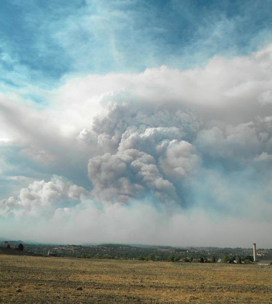
Update: Simple Micro Wind Turbine - Images: Charge Contoller


Images: I constructed this simple charge controller for the Micro Wind Turbine Project discussed previously on this Blog.
I constructed this charge controller with a few electronic components from my junk-box. Two simple indicators were added. The green LED starts lighting as soon as the wind turns the turbine. The green LED will light to full capacity/brightness once 12 volts is reached, indicating that current is available from the turbine. A zener fires a transistor, lightning the red LED when the voltage exceeds 12 volts, indicating that the turbine is charging the battery. The regulator clamps the voltage at 15 volts to prevent peaks from frying electronic equipment connected to the battery. Simple straight forward electronics, but yet very effective.
More on this project available HERE.
Subscribe to:
Posts (Atom)