Showing posts with label Heat Wave. Show all posts

Tuesday, 5 March 2013

Heatwave warning for parts of the Western Cape


HEATWAVE WARNING!!!

A heatwave alert has been issued by the SA Weather Service for the extreme north-western interior of the Western Cape. 

There is a risk of a heatwave for the next few days with daytime highs reaching over 40 Deg/C in areas. It will remain warm at night in many areas.

All indications are that this summer might be warmer than the past couple of years.

With climate change, heatwaves are likely to become more common over the next few decades and the public should take note of this.

Heatwave guidance

Consecutive hot days could be dangerous for people with heart and respiratory problems and in extreme cases, excess heat can lead to heat stroke, which can be fatal.

Ozone can be a big problem for those with breathing problems but although levels can be high during the day in a heatwave, they drop at night so staying indoors in the middle of the day can help. Keeping the home as cool as possible during hot weather and remembering the needs of friends, relatives and neighbours who could be at risk is essential.

The elderly and those who are ill, are particularly vulnerable during hot weather and the most oppressive conditions occur in our towns and cities.Windows should be kept shaded and closed when the temperature is hotter outside than inside.

Heat exhaustion can cause muscle cramps, low blood pressure, rapid pulse and nausea. It can be treated at home, by drinking water, getting into an air-conditioned room or sitting in front of a fan and misting the body with cool water. Avoid tea, coffee and alcohol.

It is very important that older people look after themselves in the warm weather.

Older people, especially those on medication, can often find coping with the heat particularly difficult.

To avoid the effects of the heat wave it is very important to avoid any unnecessary exposure to the sun during the hottest periods of the day, between 11am and 4pm.

Precautions to take when there is a summer weather heat wave:

Hydration - Drink a lot of water when you are going to be outside in the heat. A heat wave means that you will need to drink even more water than usual. Keeping yourself well hydrated during heat wave weather is essential to your health. Carry extra supplies of water with you in case you are gone longer than you think you will be gone.

Limit Time Outside - Don't spend long periods of time outside. Try to limit your outside time to 15 minutes or less. This will keep you from becoming too dehydrated or to be overcome with heat. Save outside work for when the weather changes to a cooler temperature. When temperatures are soaring, you need to worry about yourself and your health.

Hiking/Playing/Working Outdoors - Do not hike, play, walk or work outdoors when there is a heat wave in effect. It is very dangerous for you to do activities outside when the temperatures go far above anything a human can endure while being physically active. You are far better off to stay away from these outdoor activities so that you can avoid becoming a victim of the summer heat.

Swimming - It is alright to go swimming during summer heat wave weather. You should still use precautions to keep yourself well hydrated. Even though water surrounds your body while you are swimming, that doesn't hydrate your body. Remember to get out of the pool every now and then to take a drink of water. Swimming will at least keep your body cool but you still need to worry about sunburn.

Sun Block - Make sure that you put sun block on before going out in the summer heat. You are in more danger of burning your skin when a heat wave is declared than at other times. Follow the same precautions as you would in normal hot weather, but go an extra step by reapplying more often.

Drinking Alcohol - Do not drink alcohol outside when there is a heat wave. Alcohol has a tendency to dry things up rather than hydrate them. You will be in danger of getting drunk much faster if there is a heat wave and you run the risk of getting extremely ill even with a small intake of alcohol into your body.  I once did a inquest where a person got drunk, passed out and got fried by the sun.  He died as a result.

Car - Cars get much hotter than other places because they are closed off with no air circulation at all when someone isn't in them. Make sure that you lock your doors so that children can't climb inside to play and get stuck there. Children and pets die quickly when they are overcome by the heat in a car. Before going anywhere in your car during a heat wave period this summer, start the car several minutes ahead of time to cool the vehicle down before getting into it. Keep an extra supply of water with you during extremely hot weather hits this summer. You never know when something might happen and you may need to keep hydrated until help reaches you. Keep your car in good repair so there is less likelihood that you will break down along the road.  Need I say more....we already had several incidents where children were left in the car while parents were shopping.  Remember do not leave your pets in the car.

Keeping safe during summer heat wave weather is essential. Take the above precautions to help get your through the heat wave weather. Heat wave weather can last for several days but rarely lasts the entire summer. Until there is relief, take care of yourself and your family to ensure they stay healthy.

How hot was it in your town today? Send in your temperature and humidity recordings and time recorded to the SAWDOS  via Twitter: @SAWDOS1.

Tuesday, 26 February 2013

Do solar storms cause heat waves on Earth?


Although solar flares, and associated coronal mass ejections, can bombard Earth’s outermost atmosphere with tremendous amounts of energy, most of that energy is reflected back into space by the Earth’s magnetic field. Because the energy does not reach our planet’s surface, it has no measurable influence on surface temperature.


The heat wave that affected the eastern and central United States in March 2012 coincided with a flurry of solar eruptions, and it’s not unreasonable to wonder if such events are related. After all, the Sun’s energy is the source of Earth’s warmth.

But most of the energy released by solar storms like those on March 8-10 is not like the visible and ultraviolet light that penetrates Earth’s atmosphere and warms the surface. Instead, solar storms hurl bursts of electrically charged particles through space, and the particles aimed at the Earth encounter our planet’s magnetic field and upper atmosphere, the thermosphere.
 
The stream of energetic particles warms the thermosphere. Carbon dioxide and nitrogen oxide, coolants in the thermosphere, absorb the energy and then re-radiate heat back into space. A small fraction of the extra heat from the solar flare radiates to layers of the atmosphere below the thermosphere, but it is miniscule compared to the normal amount of heating the lower layers of the atmosphere already experience from incoming visible and ultraviolet sunlight.

Solar flares don’t cause heat waves, but they do have other impacts on Earth. Consequences include pretty auroras, as well as hazards. They can rain extra radiation on satellites, and increase the drag on satellites in low-Earth orbit. Increased electromagnetic activity due to solar storms can also disrupt power grids and radio communications. Passengers on commercial jets flying polar routes may be exposed to increased electromagnetic radiation.

Short-lived solar explosions don’t influence weather events like the March 2012 heat wave, but longer-term variations in solar output might affect Earth’s climate. The latter half of the seventeenth century experienced a decades-long stretch of minimal solar activity known as the Maunder Minimum, which many scientists suspect may have triggered the Little Ice Age—a cold spell that chilled the Northern Hemisphere from about 1650 to 1850.

Over the long term, however, multiple records indicate that the amount of energy the Earth receives from the Sun is quite stable. Astronomers have aimed telescopes at the Sun since the Scientific Revolution, and recent studies have reconstructed solar activity over the past three centuries. Satellites have observed the Sun since 1978, and found that solar activity varies on a roughly 11-year cycle by about one-tenth of one percent.

As for the solar storm in early March 2012, it released a substantial amount of energy, but almost all of it was re-radiated back into space, and very little penetrated the lower atmosphere. Martin Mlynczak, associate principal investigator for NASA’s Sounding of the Atmosphere using Broadband Emission Radiometry (SABER) instrument, says, “The extra energy from this storm is on the order of 100,000 times less than the energy we normally get at the Earth’s surface. It’s so small that you wouldn’t even notice it.”
Reviewer: Martin Mlynczak, NASA Langley Research Center. Title graphic based on extreme ultraviolet image of the Sun from the Solar Dynamics Observatory mission.

References

Foster, G., and Rahmstorf, S. (2011). Global temperature evolution 1979–2010. Environmental Research Letters, 6(4), 044022.
Herring, D. (2009, September 1). Climate change: Incoming sunlight. NOAA ClimateWatch Magazine. Accessed April 4, 2012.
IPS Radio and Space Services. (2012). Solar activity and weather – Is there a connection? Australian Government. Accessed April 4, 2012.
Kulmala, M., Riipinen, I., Nieminen, T., Hulkkonen, M., Sogacheva, L., Manninen, H. E., Paasonen, P., Petäjä, T., Dal Maso, M., Aalto, P. P., Viljanen, A., Usoskin, I., Vainio, R., Mirme, S., Mirme, A., Minikin, A., Petzold, A., Hõrrak, U., Plaß-Dülmer, C., Birmili, W., and Kerminen, V.-M. (2010). Atmospheric data over a solar cycle: No connection between galactic cosmic rays and new particle formation, Atmospheric Chemistry and Physics, 10, 1885-1898.
Meehl, G.A., Washington, W.M., Wigley, T.M.L., Arblaster, J.M., and Dai, A. (2003). Solar and greenhouse gas forcing and climate response in the twentieth century. Journal of Climate, 16, 426-444.
NASA. (2011, April 14). Space Weather 101. Mission: Science Webpage. Accessed April 4, 2012.
NASA. (2012, January 19). The Sun-Earth connection: Heliophysics solar storm and space weather – Frequently asked questions. Accessed April 4, 2012.
NOAA Space Weather Prediction Center. (2012, March 13). Preliminary Report and Forecast of Solar Geophysical Data, No. 1906 (pdf). Accessed April 11, 2012.
NOAA Space Weather Prediction Center. (2011, November). SWPC Frequently Asked Questions. Accessed April 4, 2012.
Phillips, T. (2012, March 22). Solar storm dumps gigawatts into Earth’s upper atmosphere. NASA Science News. Accessed April 4, 2012.
Riebeek, H. (2010, June 24). Has the Sun been more active in recent decades, and could it be responsible for some global warming? NASA Earth Observatory. Accessed April 4, 2012.
Skeptical Science. (2012). Solar activity and climate: Is the sun causing global warming? Accessed April 4, 2012.
Wang, Y.-M., Lean, J.L., Sheeley, N.R., Jr. (2005). Modeling the Sun’s magnetic field and irradiance since 1713. The Astrophysical Journal, 625, 522-538.

- NOAA

Friday, 25 January 2013

Heatwave warning for parts of South Africa ( 24 - 28 January 2013)


HEATWAVE WARNING!!!

A heatwave alert has been issued by the SA Weather Service for Gauteng and Limpopo amid warnings of extreme temperatures over the next few days.

There is a risk of a heatwave for the next few days with daytime highs reaching over 40 Deg/C in areas. It will remain warm at night in many areas. Extremely uncomfortable, extremely hot and humid conditions are forecast for Mpumalanga and Northern Cape Provinces.

All indications are that this summer might be warmer than the past couple of years.
With climate change, heatwaves are likely to become more common over the next few decades and the public should take note of this.

Heatwave guidance

Consecutive hot days could be dangerous for people with heart and respiratory problems and in extreme cases, excess heat can lead to heat stroke, which can be fatal.

Ozone can be a big problem for those with breathing problems but although levels can be high during the day in a heatwave, they drop at night so staying indoors in the middle of the day can help. Keeping the home as cool as possible during hot weather and remembering the needs of friends, relatives and neighbours who could be at risk is essential.

The elderly and those who are ill, are particularly vulnerable during hot weather and the most oppressive conditions occur in our towns and cities.Windows should be kept shaded and closed when the temperature is hotter outside than inside.

Heat exhaustion can cause muscle cramps, low blood pressure, rapid pulse and nausea. It can be treated at home, by drinking water, getting into an air-conditioned room or sitting in front of a fan and misting the body with cool water. Avoid tea, coffee and alcohol.

It is very important that older people look after themselves in the warm weather.

Older people, especially those on medication, can often find coping with the heat particularly difficult.

To avoid the effects of the heat wave it is very important to avoid any unnecessary exposure to the sun during the hottest periods of the day, between 11am and 4pm.

Precautions to take when there is a summer weather heat wave:

Hydration - Drink a lot of water when you are going to be outside in the heat. A heat wave means that you will need to drink even more water than usual. Keeping yourself well hydrated during heat wave weather is essential to your health. Carry extra supplies of water with you in case you are gone longer than you think you will be gone.

Limit Time Outside - Don't spend long periods of time outside. Try to limit your outside time to 15 minutes or less. This will keep you from becoming too dehydrated or to be overcome with heat. Save outside work for when the weather changes to a cooler temperature. When temperatures are soaring, you need to worry about yourself and your health.

Hiking/Playing/Working Outdoors - Do not hike, play, walk or work outdoors when there is a heat wave in effect. It is very dangerous for you to do activities outside when the temperatures go far above anything a human can endure while being physically active. You are far better off to stay away from these outdoor activities so that you can avoid becoming a victim of the summer heat.

Swimming - It is alright to go swimming during summer heat wave weather. You should still use precautions to keep yourself well hydrated. Even though water surrounds your body while you are swimming, that doesn't hydrate your body. Remember to get out of the pool every now and then to take a drink of water. Swimming will at least keep your body cool but you still need to worry about sunburn.

Sun Block - Make sure that you put sun block on before going out in the summer heat. You are in more danger of burning your skin when a heat wave is declared than at other times. Follow the same precautions as you would in normal hot weather, but go an extra step by reapplying more often.

Drinking Alcohol - Do not drink alcohol outside when there is a heat wave. Alcohol has a tendency to dry things up rather than hydrate them. You will be in danger of getting drunk much faster if there is a heat wave and you run the risk of getting extremely ill even with a small intake of alcohol into your body.  I once did a inquest where a person got drunk, passed out and got fried by the sun.  He died as a result.

Car - Cars get much hotter than other places because they are closed off with no air circulation at all when someone isn't in them. Make sure that you lock your doors so that children can't climb inside to play and get stuck there. Children and pets die quickly when they are overcome by the heat in a car. Before going anywhere in your car during a heat wave period this summer, start the car several minutes ahead of time to cool the vehicle down before getting into it. Keep an extra supply of water with you during extremely hot weather hits this summer. You never know when something might happen and you may need to keep hydrated until help reaches you. Keep your car in good repair so there is less likelihood that you will break down along the road.  Need I say more....we already had several incidents where children were left in the car while parents were shopping.  Remember do not leave your pets in the car.

Keeping safe during summer heat wave weather is essential. Take the above precautions to help get your through the heat wave weather. Heat wave weather can last for several days but rarely lasts the entire summer. Until there is relief, take care of yourself and your family to ensure they stay healthy.

How hot was it in your town today? Send in your temperature and humidity recordings and time recorded to the SAWDOS by clicking HERE or via Twitter: @SAWDOS1.

Heatwave hit parts of South Africa

Several parts of the country are experiencing the third day of an intense heatwave, the SA Weather Services said on Friday.

Forecaster Puseletso Mofokeng said temperatures were between 35 and 40 degrees in some parts of the Free State, the Northern Cape, North West, Limpopo, Mpumalanga and Gauteng.

While many areas were experiencing high temperatures, not all of them were in the "heatwave category".

Mofokeng said: "We look at the hottest month of the year, January, and find an average value of the highest temperature. A heatwave occurs when we record temperatures five degrees higher than the normal temperature for three consecutive days."

The heatwave was expected to last until Monday, with some rain at the weekend.

"There's a 60% chance of rain over Gauteng this evening," he said.

"Scattered showers are also forecast on Saturday and Sunday for KwaZulu-Natal, Free State, the North West, Limpopo and Mpumalanga."

- Times Live

Thursday, 24 January 2013

Heatwave warning for parts of South Africa ( 24 - 25 January 2013)


HEATWAVE WARNING!!!

A heatwave alert has been issued by the SA Weather Service amid warnings of extreme temperatures over the next two days.

There is a risk of a heatwave for today and tomorrow with daytime highs reaching over 40 Deg/C in areas. It will remain warm at night in many areas. Extremely uncomfortable, extremely hot and humid conditions are forecast for Kwazulu Natal, Eastern Cape and Northern Cape Provinces.

All indications are that this summer might be warmer than the past couple of years.
With climate change, heatwaves are likely to become more common over the next few decades and the public should take note of this.

Heatwave guidance

Consecutive hot days could be dangerous for people with heart and respiratory problems and in extreme cases, excess heat can lead to heat stroke, which can be fatal.

Ozone can be a big problem for those with breathing problems but although levels can be high during the day in a heatwave, they drop at night so staying indoors in the middle of the day can help. Keeping the home as cool as possible during hot weather and remembering the needs of friends, relatives and neighbours who could be at risk is essential.

The elderly and those who are ill, are particularly vulnerable during hot weather and the most oppressive conditions occur in our towns and cities.Windows should be kept shaded and closed when the temperature is hotter outside than inside.

Heat exhaustion can cause muscle cramps, low blood pressure, rapid pulse and nausea. It can be treated at home, by drinking water, getting into an air-conditioned room or sitting in front of a fan and misting the body with cool water. Avoid tea, coffee and alcohol.

It is very important that older people look after themselves in the warm weather.

Older people, especially those on medication, can often find coping with the heat particularly difficult.

To avoid the effects of the heat wave it is very important to avoid any unnecessary exposure to the sun during the hottest periods of the day, between 11am and 4pm.

Precautions to take when there is a summer weather heat wave:

Hydration - Drink a lot of water when you are going to be outside in the heat. A heat wave means that you will need to drink even more water than usual. Keeping yourself well hydrated during heat wave weather is essential to your health. Carry extra supplies of water with you in case you are gone longer than you think you will be gone.

Limit Time Outside - Don't spend long periods of time outside. Try to limit your outside time to 15 minutes or less. This will keep you from becoming too dehydrated or to be overcome with heat. Save outside work for when the weather changes to a cooler temperature. When temperatures are soaring, you need to worry about yourself and your health.

Hiking/Playing/Working Outdoors - Do not hike, play, walk or work outdoors when there is a heat wave in effect. It is very dangerous for you to do activities outside when the temperatures go far above anything a human can endure while being physically active. You are far better off to stay away from these outdoor activities so that you can avoid becoming a victim of the summer heat.

Swimming - It is alright to go swimming during summer heat wave weather. You should still use precautions to keep yourself well hydrated. Even though water surrounds your body while you are swimming, that doesn't hydrate your body. Remember to get out of the pool every now and then to take a drink of water. Swimming will at least keep your body cool but you still need to worry about sunburn.

Sun Block - Make sure that you put sun block on before going out in the summer heat. You are in more danger of burning your skin when a heat wave is declared than at other times. Follow the same precautions as you would in normal hot weather, but go an extra step by reapplying more often.

Drinking Alcohol - Do not drink alcohol outside when there is a heat wave. Alcohol has a tendency to dry things up rather than hydrate them. You will be in danger of getting drunk much faster if there is a heat wave and you run the risk of getting extremely ill even with a small intake of alcohol into your body.  I once did a inquest where a person got drunk, passed out and got fried by the sun.  He died as a result.

Car - Cars get much hotter than other places because they are closed off with no air circulation at all when someone isn't in them. Make sure that you lock your doors so that children can't climb inside to play and get stuck there. Children and pets die quickly when they are overcome by the heat in a car. Before going anywhere in your car during a heat wave period this summer, start the car several minutes ahead of time to cool the vehicle down before getting into it. Keep an extra supply of water with you during extremely hot weather hits this summer. You never know when something might happen and you may need to keep hydrated until help reaches you. Keep your car in good repair so there is less likelihood that you will break down along the road.  Need I say more....we already had several incidents where children were left in the car while parents were shopping.  Remember do not leave your pets in the car.

Keeping safe during summer heat wave weather is essential. Take the above precautions to help get your through the heat wave weather. Heat wave weather can last for several days but rarely lasts the entire summer. Until there is relief, take care of yourself and your family to ensure they stay healthy.

How hot was it in your town today? Send in your temperature and humidity recordings and time recorded to the SAWDOS by clicking HERE or via Twitter: @SAWDOS1.

Wednesday, 23 January 2013

How Widespread was the Australian Heatwave?


January 2013 brought record-setting heat to Australia; not just for days, but for weeks. Temperatures regularly eclipsed 45 degrees Celsius (113 degrees Fahrenheit) in multiple locations across the continent. According to the Australian Bureau of Meteorology, Australia set a new record for the highest temperature averaged across the entire nation: 40.33°C (104.59°F) on January 7. The national average reached 40.11°C (104.20°F) the following day. The overnight minimum temperature for January 7–8 also set new a record—32.36°C (90.25°F)—contributing to the hottest two-day period in Australia’s recorded history.
Each of the first eight days of 2013 were among the 20 hottest days on record. The scorching weather continued a trend of four consecutive months (September to December 2012) where temperatures were the highest on record. The persistent heat mirrors a similar pattern that developed in the continental United States in 2012.

The map above shows land surface temperature (LST) anomalies for Australia from January 1–8, 2013. LST anomalies are not absolute temperatures; instead, they show how much temperatures were above or below the average. The darkest reds show areas that were as much as 15°C (27°F) above the norm; blues show areas that were below normal; and grays depicts areas with incomplete data (often due to cloud cover). The map was built from data collected by the Moderate Resolution Imaging Spectroradiometer (MODIS) on NASA’s Aqua satellite, and the 2013 data is compared to the average for the same week as observed from 2005–2012.

Observed by satellites uniformly across the entire globe, land surface temperatures are a measure of the amount of infrared energy (thermal radiance) emitted by Earth’s surface as it is heated by daylight and cooled in the dark of night. LSTs are sometimes referred to as land “skin” temperatures, and indeed they are a reflection of how hot a surface would feel to the touch. (To learn more about LSTs and air temperatures, read: Where is the Hottest Place on Earth?)
Five scientists from the Australian Bureau of Meteorology wrote an analysis of the heatwave for The Conversation:
“Australia has always experienced heat waves, and they are a normal part of most summers. However, the current event affecting much of inland Australia has definitely not been typical. The most significant thing about the recent heat has been its coverage across the continent, and its persistence. It is very unusual to have such widespread extreme temperatures—and have them persist for so long. On those two metrics alone, spatial extent and duration, the last two weeks surpasses the only previous analogue in the historical record (since 1910)—a two-week country-wide hot spell during the summer of 1972-1973.”
During a January 2013 meeting of the Intergovernmental Panel on Climate Change (IPCC) in Hobart, Tasmania, IPCC chairman Rajendra Pachauri noted that the heatwave fit the patterns of global warming: “If you look at the trend then I think that's pretty unmistakeable,” Pachauri said, “and any proper analysis would tell you that we are heading in that direction.”
  1. References

  2. Australian Broadcasting Corporation (2013, January 15) Australian heatwave part of 'unmistakeable' global warming trend: IPCC chair. Accessed January 22, 2013.
  3. Australian Bureau of Meteorology (2013, January 14) Special Climate Statement 43 - Extreme January heat. Accessed January 22, 2013.
  4. NASA Earth Observatory (2012, April 5) Where is the Hottest Place on Earth?
  5. The Conversation (2013, January 18) What’s causing Australia’s heat wave? Accessed January 22, 2013.
NASA Earth Observatory image by Jesse Allen, using data from the Land Processes Distributed Active Archive Center (LPDAAC). Caption by Michael Carlowicz.
Instrument: 
Aqua - MODIS - NASA

Monday, 14 January 2013

Monthly heat records have increased fivefold


The Redbank North Fire burns close to the Newell Hwy near Coonabarabran, about 350km north west of Sydney, in this handout picture provided by the Rural Fire Service on January 14, 2013. Image by: HANDOUT / REUTERS

Global warming has caused monthly records for heat to increase fivefold in frequency, according to a study by scientists in Germany and Spain, published on Monday.

In parts of Europe, Africa and southern Asia, the frequency of months with record-breaking heat has surged tenfold, it said.

The evidence comes from an analysis of 131 years of monthly temperature data, monitored at 12,000 points around the world, which are stored in a NASA database.

If man-made warming is stripped out of the equation, 80 percent of the records for hottest-ever months would not have occurred, it said.

"The last decade brought unprecedented heatwaves, for instance in the US in 2012, in Russia in 2010, in Australia in 2009 and in Europe in 2003," said Dim Coumou of the Potsdam Institute for Climate Impact Research near Berlin.

On current trends for global warming, the number of new monthly heat records will be 12 times higher in 30 years than today, the researchers said.

"This doesn't mean there will be 12 times more hot summers in Europe than today -- it actually is worse," Coumou said in a press release issued by PIK.

"To count as new records, they actually have to beat heat records set in the 2020s and 2030s, which will already be hotter than anything we have experienced to date."

The study, which was co-authored by scientists at the Complutense University of Madrid, appears in the journal Climatic Change.

- Times Live

Saturday, 12 January 2013

Video: Tasmania wildfires force thousands to flee


- DILAFNEWSTV

Australia experiencing record-breaking heat and wildfires


Temperatures across Australia for the week ending for January 8, 2013. Image Credit: Australian Bureau of Meteorology

The city of Eucla, Australia recorded 119°F (48.2 °C) on January 3, 2013, highest temp since records began in 1957. As of January 8, nearly 741,000 acres have burned.

While our Northern Hemisphere is experiencing winter, the Southern Hemisphere is in the peak of its summer season. For a large portion of Australia, unusual and record-breaking heat is occurring as temperatures climb over 100 degrees Fahrenheit (over 37 degrees Celsius). On Monday, December 7, 2013, the average maximum daily temperature record for Australia was broken at around 105°F (40.33°C). This 40-year-old original record was set in December 21, 1972 at 104°F (40.17°C). According to Assistant Director of Climate Information Services, Neil Plummer, this intense heatwave has broken a lot of records. For instance, the number of consecutive days where the national average maximum daily temperature in Australia exceeded 39°C was broken the past seven days (January 2-8, 2013), almost doubling the previous record of four consecutive days in 1973. Meanwhile, dry conditions and strong winds are creating wildfires across the country.


Wildfires are burning across parts of Australia. Image Credit: NASA


NASA’s Terra satellite captured this image (top) showing numerous fires across the island on January 6, 2013. Red outlines indicate hot spots where MODIS detected the unusually warm surface temperatures associated with fires.

The heatwave has affected portions of central and southern Australia for January 2013. Temperatures will likely remain above 35°C for the upcoming week, as there is no sign of relief for these areas. The dry conditions are creating massive fires across the region. According to the Australian Bureau of Meteorology, the past four months have been unusually warm across Australia. In fact, for September to December, the average Australian maximum temperature was the highest on record with a national anomaly of +1.61°C, which was ahead of the previous record of 1.60°C set in 2002 (Records go back to 1910 across Australia). The lack of a monsoon season is resulting in warm air building across northern Australia and spilling down to the southeast. The upcoming week looks quite hot across the country as temperatures could soar past 110°F (43.3°C) for many areas. The city of Eucla recorded 119°F (48.2 °C) on January 3, 2013, making it the hottest day since records began in 1957.


Example of current temperatures (in Fahrenheit) in Australia during the first week of January.

Meanwhile, the heat and winds are contributing to the wildfires that are burning across the country. As of Tuesday, January 8, 2013, nearly 741,000 acres have burned across Australia. Wildfires have been burning in areas such as Tasmania and New South Wales. Although wildfires have been burning throughout the country, there have not been any reports of loss of life. The lack of a monsoon season, which should have already arrived, is being blamed for not only the dry weather, but also for the heat and wildfires across the region.

Bottom line: Australia is experiencing record-breaking heat across the country for the first week of January 2013. The record-breaking high temperatures are expected to continue for the upcoming week as temperatures increase over 37°C for a large majority of the area. Meanwhile, the dry conditions, which is contributing to the increase heat across the region, is also responsible for the wildfires developing across the terrain. A 40-year-old record was broken on Monday, December 7, 2013, when the average maximum daily temperature for Australia was set at 40.33°C, or around 105°F. Above average temperatures have been occurring across Australia since September 2012, and there is very little relief in sight.

- EarthSky

Friday, 11 January 2013

2012 was warmest and second most extreme year on record for the contiguous U.S.

2012 was a historic year for extreme weather that included drought, wildfires, hurricanes and storms; however, tornado activity was below average

2012 marked the warmest year on record for the contiguous United States with the year consisting of a record warm spring, second warmest summer, fourth warmest winter and a warmer-than-average autumn. The average temperature for 2012 was 55.3°F, 3.2°F above the 20th century average, and 1.0°F above 1998, the previous warmest year.

The average precipitation total for the contiguous U.S. for 2012 was 26.57 inches, 2.57 inches below average, making it the 15th driest year on record for the nation. At its peak in July, the drought of 2012 engulfed 61 percent of the nation with the Mountain West, Great Plains, and Midwest experiencing the most intense drought conditions. The dry conditions proved ideal for wildfires in the West, charring 9.2 million acres — the third highest on record.

The U.S. Climate Extremes Index indicated that 2012 was the second most extreme year on record for the nation. The index, which evaluates extremes in temperature and precipitation, as well as landfalling tropical cyclones, was nearly twice the average value and second only to 1998. To date, 2012 has seen 11 disasters that have reached the $1 billion threshold in losses, to include Sandy, Isaac, and tornado outbreaks experienced in the Great Plains, Texas and Southeast/Ohio Valley.


Note: The Annual Climate Report for the United States has several pages of supplemental information and data regarding some of the exceptional events 2012.

U.S. temperature

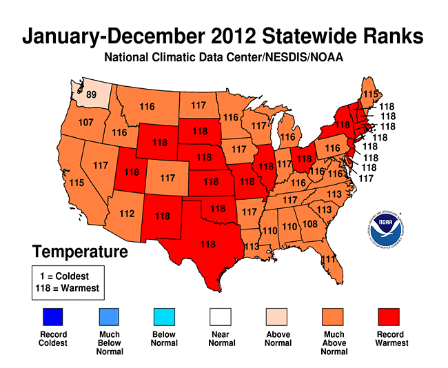
  • 2012 Statewide Temperature Ranks Map
    2012 Statewide Temperature (top) ranks
    Every state in the contiguous U.S. had an above-average annual temperature for 2012. Nineteen states had a record warm year and an additional 26 states had one of their 10 warmest.
  • On the national scale, 2012 started off much warmer than average with the fourth warmest winter (December 2011-February 2012) on record. Winter warmth limited snow with many locations experiencing near-record low snowfall totals. The winter snow cover for the contiguous U.S. was the third smallest on record and snowpack totals across the Central and Southern Rockies were less than half of normal.
  • Spring started off exceptionally warm with the warmest March on record, followed by the fourth warmest April and second warmest May. The season’s temperature was 5.2°F above average, making it easily the warmest spring on record, surpassing the previous record by 2.0°F. The warm spring resulted in an early start to the 2012 growing season in many places, which increased the loss of water from the soil earlier than what is typical. In combination with the lack of winter snow and residual dryness from 2011, the record warm spring laid the foundation for the widespread drought conditions in large areas of the U.S. during 2012.
  • The above-average temperatures of spring continued into summer. The national-scale heat peaked in July with an average temperature of 76.9°F, 3.6°F above average, making it the hottest month ever observed for the contiguous United States. The eighth warmest June, record hottest July, and a warmer-than-average August resulted in a summer average temperature of 73.8°F, the second hottest summer on record by only hundredths of a degree. An estimated 99.1 million people experienced 10 or more days of summer temperatures greater than 100°F, nearly one-third of the nation’s population.
  • Autumn and December temperatures were warmer than average, but not of the same magnitude as the three previous seasons. Autumn warmth in the western U.S. offset cooler temperatures in the eastern half of the country. Although the last four months of 2012 did not bring the same unusual warmth as the first 8 months of the year, the September through December temperatures were warm enough for 2012 to remain the record warmest year by a wide margin. 

U.S. precipitation

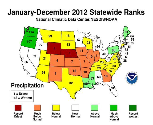
  • The nationally-averaged precipitation total of 26.57 inches was 2.57 inches below average and the 15th driest year on record for the lower 48. This was also the driest year for the nation since 1988 when 25.25 inches of precipitation was observed.
    2012 Statewide Precipitation Ranks Map 2012 Precipitation ranks
  • Each season of 2012 had precipitation totals below the 20th century average:
    • Winter brought below-average precipitation to both coasts and above-average precipitation to the Southern Plains, slightly lessening drought conditions that plagued the region in 2011. The winter precipitation total was 89 percent of normal.
    • Spring precipitation was 95 percent of the 20th century average with below-average precipitation in the Rockies and Midwest and above-average precipitation in the Northwest and Upper Midwest.
    • Summer precipitation was 88 percent of normal with dry conditions in the central United States. The West Coast, Gulf Coast, and Northeast were wetter than average.
    • Autumn was drier than average for most of the central U.S., with wet conditions in the Northwest, Ohio Valley, and Northeast. The autumn precipitation total was 85 percent of average.

Alaska and Hawaii

  • Alaska was cooler and slightly wetter than average during 2012. The year began very cold for the state with a January temperature 14.0°F below the 1971-2000 average. Each subsequent season was also cooler than average, resulting in an annual temperature 2.3°F below average. Much of 2012 was also wetter than average, and the annual precipitation total was 9.2 percent above average.
  • Drought conditions continued to plague Hawaii during 2012. At the beginning of 2012, 47.4 percent of the state was experiencing moderate-to-exceptional drought, according to the U.S. Drought Monitor. By the end of the year, the percent area experiencing moderate-to-exceptional drought expanded to 63.3 percent of the state.

Significant weather and climate events

Significant U.S. Climate Events for November 2012
Significant weather and climate events for 2012.
Click image to enlarge, or click here for the National Overview.
  • Tropical cyclone activity across the North Atlantic in 2012 as above-average with 19 named storms, ten hurricanes, and one major hurricane (Category 3 or stronger). This is the third consecutive North Atlantic tropical cyclone season with 19 named storms and ties with as the third most active season for the basin. Isaac and Sandy made landfall along the U.S. coast during 2012 causing significant impacts. Isaac brought large storm surge and torrential rains to the Gulf Coast. Sandy caused significant damage to the Northeast, with 8 million homes losing power and 131 fatalities reported.
  • The widespread drought conditions of 2012 peaked in July with approximately 61 percent of the country experiencing drought conditions. The footprint of drought during 2012 roughly equaled the drought of the 1950s which peaked at approximately 60 percent. The size of the current drought and the drought of the 1950s are smaller than the drought episodes of the 1930s. The current drought has yet to reach the intensity or duration of the 1950s and 1930s national-scale droughts.
  • Wildfire activity during 2012 was above-average with 9.2 million acres burned the third most in the 13-year record. Numerous large and destructive wildfires impacted the western U.S. throughout the year. The Waldo Canyon fire near Colorado Springs, Colorado destroyed nearly 350 homes and was the most destructive fire on record for the state. The Whitewater-Baldy Complex fire charred nearly 300,000 acres and was the largest on record for New Mexico.
  • Tornado activity during 2012 was below the 1991-2010 average of approximately 1,200. The year got off to a busy start with large tornado outbreaks in March and April causing significant damage in the Ohio Valley and Central Plains. May and June, typically the most active tornado months of the year, both had less than half of average tornado counts. The final 2012 tornado count will likely be less than 1,000 — the least since 2002.


Overview

The State of the Climate Report is a collection of monthly summaries recapping climate-related occurrences on both a global and national scale. The report is composed of the following sections:

Thursday, 10 January 2013

Heatwave warning for parts of South Africa (8 - 10 January 2013)


HEATWAVE WARNING!!!

A heatwave alert has been issued by the SA Weather Service amid warnings of extreme temperatures over the next few days.

There is a risk of a heatwave from today till Thursday with daytime highs reaching over 40 Deg/C in areas. It will remain warm at night in many areas.

More information available HERE.

Wednesday, 9 January 2013

Heatwave warning for parts of South Africa ( 9 - 10 January 2013)


HEATWAVE WARNING!!!

A heatwave alert has been issued by the SA Weather Service amid warnings of extreme temperatures over the next few days.

There is a risk of a heatwave from today till Thursday with daytime highs reaching over 40 Deg/C in areas. It will remain warm at night in many areas.

More information available HERE.

Tuesday, 8 January 2013

Heatwave warning for parts of South Africa ( 8 - 10 January 2013)


HEATWAVE WARNING!!!

A heatwave alert has been issued by the SA Weather Service amid warnings of extreme temperatures over the next few days.

There is a risk of a heatwave from today till Thursday with daytime highs reaching over 40 Deg/C in areas. It will remain warm at night in many areas.

All indications are that this summer might be warmer than the past couple of years.
With climate change, heatwaves are likely to become more common over the next few decades and the public should take note of this.

Heatwave guidance

Consecutive hot days could be dangerous for people with heart and respiratory problems and in extreme cases, excess heat can lead to heat stroke, which can be fatal.

Ozone can be a big problem for those with breathing problems but although levels can be high during the day in a heatwave, they drop at night so staying indoors in the middle of the day can help. Keeping the home as cool as possible during hot weather and remembering the needs of friends, relatives and neighbours who could be at risk is essential.

The elderly and those who are ill, are particularly vulnerable during hot weather and the most oppressive conditions occur in our towns and cities.Windows should be kept shaded and closed when the temperature is hotter outside than inside.

Heat exhaustion can cause muscle cramps, low blood pressure, rapid pulse and nausea. It can be treated at home, by drinking water, getting into an air-conditioned room or sitting in front of a fan and misting the body with cool water. Avoid tea, coffee and alcohol.

It is very important that older people look after themselves in the warm weather.

Older people, especially those on medication, can often find coping with the heat particularly difficult.

To avoid the effects of the heat wave it is very important to avoid any unnecessary exposure to the sun during the hottest periods of the day, between 11am and 4pm.

Precautions to take when there is a summer weather heat wave:

Hydration - Drink a lot of water when you are going to be outside in the heat. A heat wave means that you will need to drink even more water than usual. Keeping yourself well hydrated during heat wave weather is essential to your health. Carry extra supplies of water with you in case you are gone longer than you think you will be gone.

Limit Time Outside - Don't spend long periods of time outside. Try to limit your outside time to 15 minutes or less. This will keep you from becoming too dehydrated or to be overcome with heat. Save outside work for when the weather changes to a cooler temperature. When temperatures are soaring, you need to worry about yourself and your health.

Hiking/Playing/Working Outdoors - Do not hike, play, walk or work outdoors when there is a heat wave in effect. It is very dangerous for you to do activities outside when the temperatures go far above anything a human can endure while being physically active. You are far better off to stay away from these outdoor activities so that you can avoid becoming a victim of the summer heat.

Swimming - It is alright to go swimming during summer heat wave weather. You should still use precautions to keep yourself well hydrated. Even though water surrounds your body while you are swimming, that doesn't hydrate your body. Remember to get out of the pool every now and then to take a drink of water. Swimming will at least keep your body cool but you still need to worry about sunburn.

Sun Block - Make sure that you put sun block on before going out in the summer heat. You are in more danger of burning your skin when a heat wave is declared than at other times. Follow the same precautions as you would in normal hot weather, but go an extra step by reapplying more often.

Drinking Alcohol - Do not drink alcohol outside when there is a heat wave. Alcohol has a tendency to dry things up rather than hydrate them. You will be in danger of getting drunk much faster if there is a heat wave and you run the risk of getting extremely ill even with a small intake of alcohol into your body.  I once did a inquest where a person got drunk, passed out and got fried by the sun.  He died as a result.

Car - Cars get much hotter than other places because they are closed off with no air circulation at all when someone isn't in them. Make sure that you lock your doors so that children can't climb inside to play and get stuck there. Children and pets die quickly when they are overcome by the heat in a car. Before going anywhere in your car during a heat wave period this summer, start the car several minutes ahead of time to cool the vehicle down before getting into it. Keep an extra supply of water with you during extremely hot weather hits this summer. You never know when something might happen and you may need to keep hydrated until help reaches you. Keep your car in good repair so there is less likelihood that you will break down along the road.  Need I say more....we already had several incidents where children were left in the car while parents were shopping.  Remember do not leave your pets in the car.

Keeping safe during summer heat wave weather is essential. Take the above precautions to help get your through the heat wave weather. Heat wave weather can last for several days but rarely lasts the entire summer. Until there is relief, take care of yourself and your family to ensure they stay healthy.

How hot was it in your town today? Send in your temperature and humidity recordings and time recorded to the SAWDOS by clicking HERE or via Twitter: @SAWDOS1.

Sunday, 30 December 2012

Job fitness tests suspended after deaths

Johannesburg: KwaZulu-Natal transport MEC Willies Mchunu has suspended all tests for Road Traffic Inspectorate jobs after seven people died, SABC radio news reported on Sunday.

In a statement on Saturday he said he would investigate the incident whereby "scores" of people who were trying to get a job at the road traffic inspectorate, collapsed during a fitness test.

"More than 34 000 applicants qualified for the 90 trainee posts which were advertised," said Mchunu in a statement.

He said that 15 600 applicants attended a fitness test at the Harry Gwala Stadium on Thursday, and a similar number attended on Friday.

"Scores of them could not cope with the hot weather condition and collapsed."

Many were taken to hospital.

- SAPA/News24

SAWDOS: Guess it is a bit late to suspend fitness tests now - 7 already dead!!

Saturday, 29 December 2012

Six die after taking part in a KwaZulu-Natal traffic department recruitment fitness test

Johannesburg - Six people have died from suspected dehydration after taking part in a KwaZulu-Natal traffic department recruitment fitness test, SABC news reported on Saturday.

Another person apparently committed suicide in frustration after the test, the news station reported.

Provincial Transport, Community Safety and Liaison MEC Willies Mchunu could not be reached for comment about the deaths.

However, in a statement on Saturday he said he would investigate the incident whereby "scores" of people who were trying to get a job at the road traffic inspectorate, collapsed during a fitness test.

"More than 34 000 applicants qualified for the 90 trainee posts which were advertised," said Mchunu in a statement.

He said that 15 600 applicants attended a fitness test at the Harry Gwala Stadium on Thursday, and a similar number attended on Friday.

"Scores of them could not cope with the hot weather conditions and collapsed."

Many were taken to hospital.

Mchunu said that he would meet with those in charge of the test on Saturday.

"We regret any injuries or loss of lives as a result of the fitness test," he said.

- SAPA

SAWDOS: This is really unbelievable. 6 dead after extreme humid and very hot weather in Kwazulu Natal. People in charge will have to really explain why this event took place after a warning was issued of extremely uncomfortable humid conditions. Yet they went ahead with the event and candidates had to run 4km in these conditions without water along the route. I saw video footage of the event. Shocking to say the least. Those who organized this event should be held accountable for the deaths of these people. The SAWDOS would like to extend it's condolences to the family and friends of the deceased.

Thursday, 20 December 2012

Heat Wave:Western Cape

A heatwave warning has been issued by the SA Weather Service for the Western Cape amid warnings of extreme temperatures over the next two days.

  • Current warning: Western Cape Province
  • Updated: 20/12/2012 04:50:47
  • Validity: 2012-12-20 to 2012-12-20
  • Type: Warning. Take action
  • Subject: Heatwave, extremely hot and uncomfortable conditions
  • Detail: 1. A heat wave with persistently high temperatures is expected over the West Coast. 2. Extremely uncomfortable, humid and hot conditions will be experienced over the west Coast District and Cape Winelands. 3. Extremely hot conditions are expected over the West Coast District.


Daytime highs of  close to 40 Deg/C is forecasted in areas. It will remain warm at night in many areas.

Please be on the lookout for fires in the Western Cape and report them to the emergency services as soon as possible. This will assist fire fighters to extinguish the fire as soon as possible thereby preventing it from spreading and getting out of control. The reaction time is absolutely crucial.


Heatwave guidance

Consecutive hot days could be dangerous for people with heart and respiratory problems and in extreme cases, excess heat can lead to heat stroke, which can be fatal.

Ozone can be a big problem for those with breathing problems but although levels can be high during the day in a heatwave, they drop at night so staying indoors in the middle of the day can help. Keeping the home as cool as possible during hot weather and remembering the needs of friends, relatives and neighbours who could be at risk is essential.

The elderly and those who are ill, are particularly vulnerable during hot weather and the most oppressive conditions occur in our towns and cities.Windows should be kept shaded and closed when the temperature is hotter outside than inside.

Heat exhaustion can cause muscle cramps, low blood pressure, rapid pulse and nausea. It can be treated at home, by drinking water, getting into an air-conditioned room or sitting in front of a fan and misting the body with cool water. Avoid tea, coffee and alcohol.

It is very important that older people look after themselves in the warm weather.

Older people, especially those on medication, can often find coping with the heat particularly difficult.

To avoid the effects of the heat wave it is very important to avoid any unnecessary exposure to the sun during the hottest periods of the day, between 11am and 4pm.

- SAWDOS

Sunday, 16 December 2012

2012 set to be warmest year ever recorded in US


2012 is likely to break 1998 for the warmest year ever recorded since record keeping began in the contiguous United States.

The National Climatic Data Center released their climate report for the contiguous United States for the month of November 2012. In this report, they mentioned that the average temperature for the contiguous U.S. for November 2012 was 44.1 degrees Fahrenheit (°F), which was 2.1°F above the 20th century average. The above average temperatures makes November 2012 the 20th warmest November on record. If you lived west of the Mississippi River, temperatures were well above average from California, Washington, Iowa, and south into Texas. However, the majority of the eastern United States experienced cooler than average temperatures.

The most stunning information from this report is that even if December brought upon record cold temperatures for the U.S., it would still make 2012 rank as the warmest year ever recorded in the contiguous United States. As of now, the United States as a whole is beating out 1998 as the warmest year ever recorded by approximately 1°F.

For November 2012, major warmth dominated areas west of the Mississippi River with Arizona, Colorado, New Mexico, Utah, and Wyoming having November temperatures among their ten warmest. In the eastern United States, colder air from Canada dominated the region with many areas receiving cooler than average temperatures for the month of November 2012. North Carolina tied 10th coolest November on record, with a statewide-averaged temperature 3.5°F below average. November 2012 ranked as the eighth driest November on record with an average rainfall amount of 1.19 inches, which was 0.93 inches below the long-term average. The Intermountain West, the Plains, the Midwest, and along the entire East Coast experienced drier conditions than normal. Overall, the warmth in November pretty much sealed the deal for 2012 to become the warmest year ever recorded in the contiguous United States.

This chart ranks the temperature anomalies for the contiguous U.S. from 1895 through November 2012. 2012 is a huge outlier compared to the previous years, including 1998 which was considered the warmest year ever recorded since 1895. Image Credit: NOAA

I believe the chart above depicts exactly how warm 2012 has been for the contiguous United States. As of the end of November, temperatures have been slightly over 3°F above average. 1998, which was the warmest year ever recorded since record keeping began in 1895, had an average temperature for the contiguous U.S. of 54.32°F. 2012 is currently having an average temperature of 55.34°F. We are not only breaking 1998′s record warmth, but we are crushing 1998 by over a degree. The first half of December has already brought upon fairly warm temperatures across a large majority of the United States, and it is nearly impossible for 2012 to drop below 1998 even if the second half of December brought upon record cold temperatures. Is global warming to blame for these temperatures? To give you an idea, seven of the top ten warmest years in the contiguous U.S. have occurred in the past 15 years. There are definitely natural cycles that influence the weather patterns across the globe, but it is hard to argue that global warming did not have a role or influence with the record warmth across the country. Of course, if you ask parts of Asia or Europe about temperatures, they would argue that temperatures were below average. It is important to note that Earth likes to maintain a balance, so if one area is receiving record warmth, another area is bound to experience very cold temperatures.


Comparison of the top five warmest years to date in the contiguous U.S. compared to January through November 2012. The 2012 line ends showing where it will end up in December assuming how cold or warm it could get by the year’s end. Image Credit: NOAA/NCDC

Bottom line: 2012 will go down as the warmest year ever recorded in the contiguous United States since record keeping began in 1895. A warm 2011-2012 winter with extreme warmth in March and July contributed greatly to making 2012 the warmest year ever recorded. Prior to this year, 1998 was the warmest year ever recorded in the contiguous U.S. with the country averaging 54.32°F. Today, the average temperature for the contiguous U.S. in 2012 is 55.34°F. I find this to be truly remarkable, and it shows you how extreme 2012 has been regarding our weather in the United State

- Earth Sky

Monday, 8 October 2012

Heat wave sweeps through parts of SA

JOHANNESBURG - The South African Weather Service on Sunday warned that heat wave conditions will persist across various parts of the country including Gauteng.

The Free State, Mpumalanga, Limpopo and KwaZulu-Natal and Gauteng will experience extreme hot conditions.

Soaring temperatures are expected across the province with Pretoria reaching an expected high of 34 degrees.

The mercury is however set to drop again from Monday.

- EWN

Sunday, 7 October 2012

Parts of SA set to heat up

Johannesburg - Some provinces will experience extremely high weather conditions throughout the weekend as the SA Weather Services warned of a heatwave across parts of the country on Saturday.

The Free State, Gauteng, KwaZulu-Natal and the North West provinces will experience persistently high temperatures.

Mpumalanga and Limpopo will experience uncomfortable humid conditions, it warned.


- SAPA/News24

Sunday, 5 August 2012

Global warming blamed for heat

Washington - An analysis by a top government scientist says the extreme heat and drought seen in the US, Europe and other regions in recent years must be global warming.

Specifically the study by Nasa scientist James Hansen blames climate change for last year's drought in Texas and Oklahoma, the 2010 heat wave in Russia and the 2003 European heat wave that led to tens of thousands of deaths.

Hansen told The Associated Press in an interview that the world is now experiencing scientific fact.

Hansen's research is respected by other climate scientists. But he is also an activist who has pushed for curbing greenhouse gases. Some experts don't expect the new study to change any minds. Hansen's work was published online on Saturday in the Proceedings of the National Academy of Science.

- AP/News24