Showing posts with label Weather Images. Show all posts

Sunday, 13 January 2013

Best Photos of the Week: SAWDOS Facebook Weather Observation - South Africa : 7 - 12 January 2013


Flash flooding Alberton - Janine Williams


Zs-one Tp Jakes - 06h30, 8 Jan 2013 St James, False Bay coast.


Jan-Henk Van Vuuren - Newcastle, Kzn


Heidi Van Rooyen - GLENFERN FARM LOWER LOTENI, NOTTINGHAM RD, KZN


Nick Roux - Just to show how much rain South Africa has seen in the past 2 years. A photo of Kouga Dam in the Eastern Cape taken today, 100% full, 126 million cubic meters of water. Two years ago this dam was at less than 30% for a many many months.


Marida Jooste - Kestell swaar weer,het fyn hael tussen Senekal en Bethlehem op die pad gekry.


Dee de Souza - 12 mins drive outside of Carolina the sun was beginning to sink with spectacular display of the suns rays through the storm clouds. 29 Dec 2012, 6.47pm


Dee de Souza - 40 mins later, the last sunset of the year, over Barberton. 31 Dec 2012. 6.48pm


Zs-one Tp Jakes - Looking at Table Mountain at 08h30 this morning (10-1-2013). a bit of drizzle in Cape Town.


Paul F Sander - Currently 2013.01.10 at 15:18 south west to Heidelberg Gauteng. Now its pouring with a very strong wind.


Sandra Pinto - Ladysmith KZN


Paul F Sander - Currently 2013.01.10 at 15:00 south west to Heidelberg Gauteng.


Francis Proudfoot Lanham - Beautiful sky near the Lesotho Border, by Fouriesburg.


Julie Venter - Pyrocumulus cloud formed above a fire in Port Elizabeth


Ian D. Samson - Looking North-East from Windsor West ... must be over Rivonia, Sunninghill.


Ubaids Ibnul Qari - Before sunset yesterday... 10/01/2013


Gerrit Naude - Near Bushlands, Hluhluwe. Looking south towards Charters' Creek and Mtubatuba-8h45.


Jaco Ludick - Sasolburg @ 12 January 2013, 05:15 Morning


Lorna Scheepers - Alberton this morning


Ubaids Ibnul Qari - Exiting Azaadville this morning


Fred Calitz - The beautiful double rainbow over Polokwane


Diana Kitshoff - Sunset 11 Jan 2013 Port Elizabeth....

For more information, news, observation reports and images visit the SAWDOS Facebook Group by clicking HERE.

Sunday, 30 September 2012

Images: Weather Observation - SAWDOS Facebook Observers

Sunrise at Noordhoek Ski Boat Club this morning. - Nick Cadle

Moon over Knysna - Penny Foyn

Big storm Ladysmith - Joe Bendall

Looking south west at 13.08 — at Settlers Park, Port Elizabeth. - Jennifer Anne Church Joubert

Tree clouds! Assagay - Dee de Souza

Mist in Assagay - Dee de Souza

Volksrust MPA, big storm blowing in on a very strong wind - Marianne De Bruyn

Cloud over Colenso with rumbling and thunder going on, looks ominous - Francis Lanham Proudfoot

Taken at Bluewater Bay Beach at about 06:05, just before the heavy clouds started to roll in. - Nick Cadle

Durban Harbour - Dee de Souza

Sunrise (almost), Clovelly, Cape Town looking SE over False Bay - Jakes ZS1TB

Overlooking Valley of a Thousand Hills - Dee de Souza

Early morning, (6:43) at Pollock Beach, Port Elizabeth. - Diana Kitshoff

Early morning, (6:43) at Pollocks Beach, Port Elizabeth. - Ryna Bakkes

Saturday, 29 September 2012

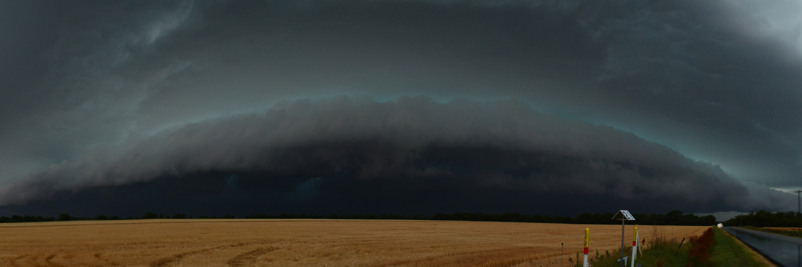
Storms Approaching

download large image (465 KB, JPEG, 3102x1034) 


Editor's Note: The top image was one of five winners from an extreme weather photo contest sponsored by NASA’s Global Precipitation Measurement mission.
In 2012, south central Kansas endured bone-dry conditions throughout May, a month when ample rains usually wash over the region (3.80 inches/96.52 millimeters on average). By May 29, Wichita had recorded just 0.63 inches (16.00 millimeters) of rain, putting the city on track for its second driest May on record.
But on May 30, the dry spell ended in dramatic fashion. The three key ingredients for thunderstorms—humid air, atmospheric instability, and convection—came together in the afternoon to create fierce storms. Around 3 p.m., storms began to develop in large numbers north and west of the city. By 5 p.m., a band of intense storms had formed a squall line, which forecasters warned could turn into a derecho. The system was racing south toward Wichita at up to 70 miles (113 kilometers) per hour, dumping torrential rains and hail the size of ping-pong balls.
The leading edge was approaching Kechi, a small city 10 miles north of Wichita, when storm-chasing photographer Brian Johnson captured the images he used to stitch together this ominous view of the approaching weather (top image). The panorama view shows a low-elevation, wedge-shaped cloud known as a shelf cloud forming over a freshly-cut wheat field. Shelf clouds (a type of arcus cloud) often have damaging winds underneath them and form just ahead of squall lines in an area called the gust front.
On the same day, the Moderate Resolution Imaging Spectroradiometer (MODIS) instrument on NASA’s Aqua satellite was orbiting 438 miles (705 kilometers) overhead. A few hours before Johnson snapped his photographs, MODIS acquired this (bottom) view of the developing storm system.The large white cloud in the upper part of the image is one of the numerous storm clouds that billowed up over the area that afternoon as warm, moist air from the surface rose rapidly toward the stratosphere. (Watch this animation to see the storm clouds evolve over time).
“There is an open farm field roughly two miles from my house...I sat there for about 20 minutes before this large squall line pushed through the clouds,” Johnson wrote on a blog that chronicles his storm chasing. “I was hit with a pretty good gust front as it got closer, but as the winds increased, I decided to get to shelter. This photo was one of the last ones I took.“
NASA image courtesy LANCE MODIS Rapid Response Team at NASA GSFC. Photograph by Brian Johnson. Caption by Adam Voiland.
Instrument: 
Photograph - NASA

Monday, 24 September 2012

Images: Weather Observation - SAWDOS Facebook Observers

Sunset Port Elizabeth Lorraine area - Diana Kitshoff

Sunrise Port Elizabeth Lorraine area - Diana Kitshoff

Wolke in Kestell lyk nie gaaf nie. - Marinda Jooste

Cape Town - Jakes ZS1TP

Lyk of die palmbome se toppe aan die brand is van die rooi weerkaatsing - Johann Pretorius, Despatch

Kestell gaan dalk reen kry. - Marinda Jooste

 Hillcrest overlooking St Hillier lake towards the M13 to Pinetown/Durban. - Dee de Souza


In Paradise Beach, Eastern Cape - Jennifer Anne Church Joubert

Cape Town - Photo taken from the top of Ou Kaapse Weg (Silvermine) - looking north - Jakes ZS1TP

Saturday, 15 September 2012

Foto's: Weerlig oor Pretoria (13 September 2012)


Ek het hierdie twee foto's geneem tydens gisteraand (13/9/2012) se elektriese storm oor Pretoria. Waarnemer: Andy Rabie.